24-Hour Public Weather Forecast Issued at 4:00 AM
The latest 24-hour public weather forecast released at 4:00 AM on December 10, 2023, sheds light on the prevailing meteorological conditions in the Philippines. This comprehensive report, provided by the Philippine Atmospheric, Geophysical, and Astronomical Services Administration (PAGASA), aims to keep the public informed about the anticipated weather patterns and potential impacts across the nation.
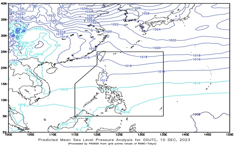
Synopsis: The dominant influence of strong easterlies is instigating notable changes in the overall weather conditions throughout the country.
Weather Description: In key locations such as Metro Manila and various other regions, the current weather conditions are described as partly cloudy to cloudy skies with sporadic instances of rain showers or thunderstorms. This atmospheric phenomenon is attributed to the presence of easterlies and localized thunderstorms. The consequential impact includes the potential for rapid flooding or landslides, particularly during episodes of intense thunderstorms.
Wind and Coastal Conditions: Across the entire country, the wind conditions are characterized by light to moderate speeds, emanating from the east to northeast directions. Simultaneously, coastal waters are expected to exhibit slight to moderate conditions, with wave heights ranging from 0.6 to 2.5 meters.
SLPRSD Regional Weather Forecast: The Regional Weather Forecast from the Southern Luzon PAGASA Regional Services Division (SLPRSD), released at 5:00 AM on December 10, 2023, provides a detailed outlook that remains valid until 5:00 AM the following day.
Continued Influence of Easterlies: The synopsis reaffirms that the weather conditions across the country persist in being significantly influenced by the Easterlies.
Regional Weather Description: Specifically focusing on the regions of Bicol, Northern Samar, Oriental Mindoro, Marinduque, and Romblon, the forecast indicates partly cloudy to cloudy skies with isolated rain showers or thunderstorms. The primary drivers of these weather conditions are the easterlies and localized thunderstorms. The anticipated impact includes light to moderate winds from the east to northeast, accompanied by slight to moderate sea conditions in these mentioned areas.

This 24-hour public weather forecast is a vital tool for individuals, communities, and relevant authorities to prepare for and respond to dynamic weather conditions. As we navigate the atmospheric nuances brought about by easterlies and localized thunderstorms, staying informed and proactive is key to mitigating potential risks and ensuring the safety and well-being of the populace. Stay tuned for further updates from PAGASA as they continue to monitor and analyze the evolving weather patterns across the archipelago.