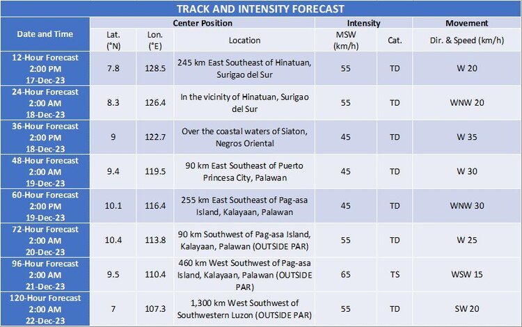
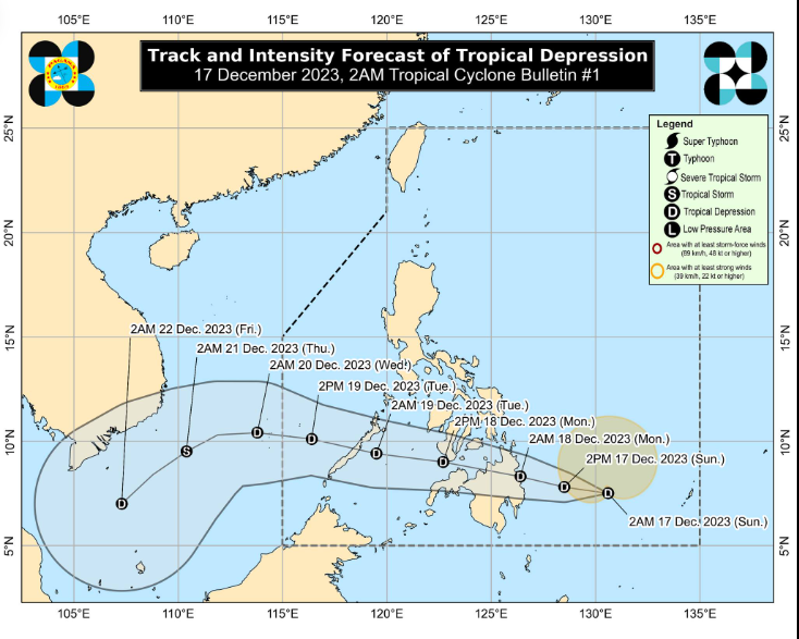
At present, the center of Typhoon KABAYAN is located approximately 460 kilometers east-southeast of Hinatuan, Surigao del Sur, at 7.5°N, 130.4°E. It has maximum sustained winds of 55 km/h near the center, gusts of up to 70 km/h, and a central pressure of 1002 hPa. Its movement is westward at 10 km/h.
Noticeable strong winds extend outward up to 350 km from the center, which may bring intense rainfall and increased waves to the affected areas.

Hope for Resilience: Resisting Damage
The Philippine Atmospheric, Geophysical, and Astronomical Services Administration (PAGASA) has issued warnings regarding the impact of Typhoon KABAYAN, and various local authorities in different regions are preparing for potential damages it may cause.
As of the moment, Typhoon KABAYAN is bringing rains ranging from 39 to 61 km/h, which may result in minimal to minor damages to life and property. Nevertheless, PAGASA advises residents to be prepared for possible increased rainfall and precipitation that may lead to flooding and landslides.

Risks in High-Risk Areas
In high or mountainous areas, there is a higher likelihood of flooding and landslides. Authorities remind residents in these areas to be vigilant and cautious. Furthermore, higher amounts of rainfall are expected in areas that have experienced intense and continuous rainfall in the past few days.
Caution Amid Excessive Danger
The public weather advisory emphasizes the need for residents to exercise caution regarding the potential effects of Typhoon KABAYAN, especially with heavy rainfall and precipitation that may lead to flooding and landslides. It is crucial to follow the issued warnings and adhere to instructions from local authorities.

Coordination and collaboration need to be maintained among citizens, local government units, and various government agencies to ensure the safety of everyone amidst the onslaught of Typhoon KABAYAN.
