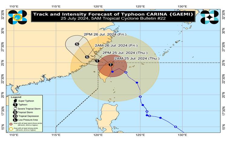
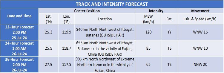
Issued at 5:00 AM on 25 July 2024, Typhoon Carina is currently crossing Taiwan and nearing the northern boundary of the Philippine Area of Responsibility (PAR). As of 4:00 AM, the center of the typhoon was located approximately 465 km north of Itbayat, Batanes, near Hsinchu County, Taiwan. It is moving northward at 20 km/h, with maximum sustained winds of 150 km/h near the center, gustiness up to 250 km/h, and a central pressure of 960 hPa.
Tropical Cyclone Wind Signals in Effect
Tropical Cyclone Wind Signal No. 1 is in effect over Batanes, indicating strong winds with speeds ranging from 39 to 61 km/h (Beaufort scale 6 to 7). The lead time for this warning is 36 hours, and the potential impacts of these winds are minimal to minor threats to life and property. Local winds may be stronger in coastal and upland areas, while sheltered areas will experience less intense winds.
Heavy Rainfall and Severe Winds
Typhoon Carina is less likely to bring heavy rainfall to any part of the Philippines directly. However, the enhanced Southwest Monsoon will cause moderate to intense rainfall in the western parts of Luzon from today through Saturday. Areas particularly affected include Batanes, Babuyan Islands, Ilocos Region, Cordillera Administrative Region, Nueva Vizcaya, Quirino, the eastern portion of Isabela, Central Luzon, Metro Manila, CALABARZON, MIMAROPA, Bicol Region, Western Visayas, Negros Occidental, and Northern Samar today and tomorrow. On Saturday, the regions affected will be Batanes, Ilocos Region, Zambales, Bataan, Marinduque, Romblon, and Kalayaan Islands.
Hazards Affecting Coastal Waters
A Gale Warning is in effect over the coastal waters of Batanes, Babuyan Islands, Ilocos Norte, Ilocos Sur, and northwestern Cagayan. Sea travel is risky for small seacrafts, including all types of motorbancas. Additionally, rough seas (2.5 to 4.0 m) are expected over the western seaboard of Central Luzon due to Carina and the enhanced Southwest Monsoon. Moderate to rough seas are also forecast over the northern and western seaboards of Northern Luzon, the western seaboard of Southern Luzon, and the eastern seaboard of Northern Luzon. Mariners of small seacrafts are advised to avoid navigation under these conditions.
Track and Intensity Outlook
Typhoon Carina is expected to exit the PAR this morning, cross the Taiwan Strait, and make its final landfall over southeastern China this afternoon or evening. As it interacts with Taiwan’s mountainous terrain and southeastern China’s landmass, Carina will continue to weaken.
The public and disaster risk reduction and management offices are advised to take necessary measures to protect life and property. Those in highly susceptible areas should follow evacuation and other instructions from local officials. For updates on heavy rainfall warnings, thunderstorm advisories, and other weather-related information, stay tuned to PAGASA’s announcements.