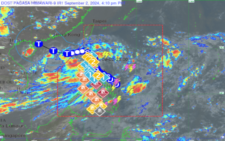
Tropical Storm Enteng (international name: Yagi) made landfall in the vicinity of Casiguran, Aurora, the state weather bureau PAGASA reported in its latest bulletin. The storm, which was last located over the coastal waters of Casiguran, is moving north-northwestward at a speed of 20 kilometers per hour (kph). With sustained winds of 85 kph and gusts reaching up to 105 kph, Enteng is expected to maintain its strength as a tropical storm while traversing mainland Luzon.

PAGASA forecasts that Tropical Storm Enteng will continue on a northwestward trajectory, crossing northern Luzon before emerging over the Luzon Strait by late morning on September 3. The storm is projected to exit the Philippine Area of Responsibility (PAR) by Wednesday, September 4, but not before impacting several areas across Luzon with strong winds and heavy rainfall.
Wind Signals in Effect
In anticipation of the storm’s effects, PAGASA has hoisted various Tropical Cyclone Wind Signals across Luzon.
Signal No. 2 has been raised in the following areas:
- Ilocos Norte
- Apayao
- Eastern portion of Kalinga (including Rizal, Pinukpuk, City of Tabuk)
- Cagayan, including Babuyan Islands
- Isabela
- Quirino
- The northern portion of Aurora (including Casiguran, Dilasag, Dinalungan, Dipaculao, Baler)
- Polillo Islands
- The northern portion of Camarines Norte (including Santa Elena, Capalonga, Jose Panganiban, Paracale, Vinzons)
In these areas, winds ranging from 62 to 88 kph are expected, posing a minor to moderate threat to life and property. Residents are advised to take necessary precautions.
Signal No. 1 is in effect for the following areas:
- Batanes
- Rest of Ilocos Norte
- Ilocos Sur
- La Union
- The eastern portion of Pangasinan
- Abra
- Rest of Kalinga
- Mountain Province
- Ifugao
- Benguet
- Nueva Vizcaya
- Rest of Aurora
- Nueva Ecija
- The eastern portion of Pampanga
- Eastern portion of Bulacan
- Metro Manila
- Rest of Quezon
- Rizal
- Laguna
- The eastern portion of Batangas
- Marinduque
- Rest of Camarines Norte
- Camarines Sur
- Catanduanes
- Albay
These areas can expect winds between 39 and 61 kph, with minimal to minor impacts anticipated.
Precautionary Measures
PAGASA advises residents in affected areas, particularly those under Signal No. 2, to secure loose objects and prepare for possible power outages. Local disaster risk reduction and management offices have been activated to monitor the situation and provide timely assistance.
As Tropical Storm Enteng continues its path across Luzon, the public is urged to stay informed through official PAGASA updates and heed the warnings issued by local authorities.
