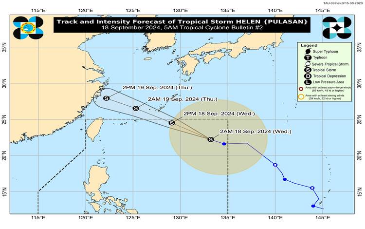
Issued at 5:00 AM, 18 September 2024
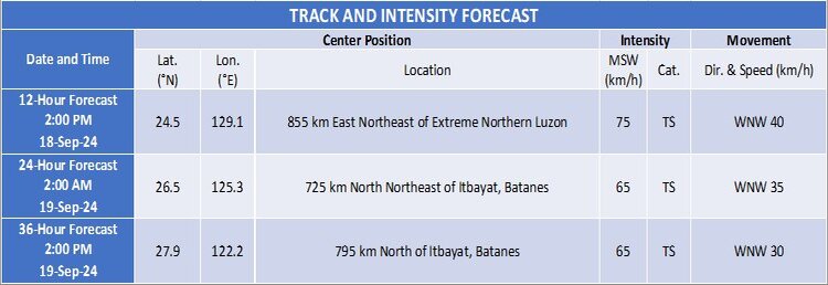
Tropical Storm Helen (international name: Pulasan) continues to track west-northwestward over the Philippine Sea, enhancing the southwest monsoon (Habagat) and bringing strong winds and heavy rainfall to several regions across the country. As of 4:00 AM today, the storm was located 1,150 km east-northeast of Extreme Northern Luzon, with maximum sustained winds of 85 km/h near the center and gusts reaching up to 105 km/h.
Current Situation and Movement
According to the Philippine Atmospheric, Geophysical and Astronomical Services Administration (PAGASA), Tropical Storm Helen is currently moving west-northwestward at a speed of 25 km/h. Strong to gale-force winds extend outward up to 650 km from its center, making sea conditions particularly dangerous for small sea vessels in affected areas.
At the time of this bulletin, no Tropical Cyclone Wind Signal (TCWS) is in effect, as Helen remains distant from the Philippine landmass. However, it is enhancing the effects of the southwest monsoon, which will impact several regions across the country.
Impact of Southwest Monsoon and Severe Winds
While Helen is not expected to make landfall in the Philippines, the enhanced southwest monsoon, in combination with Tropical Storm Gener, will result in severe weather conditions, particularly strong to gale-force winds and heavy rainfall over many parts of Luzon, the Visayas, and Mindanao.
- Today (18 September): Strong winds are expected to impact Zambales, Bataan, Pampanga, Bulacan, Metro Manila, CALABARZON, MIMAROPA, Bicol Region, Visayas, Zamboanga Peninsula, Northern Mindanao, Caraga, and Davao Region.
- Tomorrow (19 September): Severe winds may affect the Ilocos Region, Isabela, Aurora, Zambales, Bataan, Metro Manila, CALABARZON, MIMAROPA, Bicol Region, Western Visayas, Negros Island Region, and Zamboanga Peninsula.
- Thursday (20 September): Winds are forecast to impact the Ilocos Region, Isabela, Aurora, Zambales, Bataan, Cavite, Batangas, Quezon, Occidental Mindoro, Marinduque, and Romblon.
Residents in these areas, especially those in coastal and upland regions, are advised to remain vigilant and take precautions as strong gusts and heavy rainfall could trigger landslides, flash floods, and rough sea conditions.
Hazards Affecting Coastal Waters
Due to the influence of the enhanced southwest monsoon and Tropical Storm Helen, a gale warning has been raised for several coastal areas. As per Gale Warning No. 8 issued earlier this morning, risky sea conditions are expected over the western seaboard of Central Luzon, Southern Luzon, and the Visayas.
In addition, rough seas with waves of 1.0 to 3.5 meters are forecast in the northern seaboards of Cagayan Valley and Zamboanga Peninsula, the seaboards of Caraga and Ilocos Region, and the eastern seaboards of the Bicol Region, Davao Region, and Eastern Visayas. Mariners and small sea vessels, including motorbancas, are strongly discouraged from venturing out to sea due to these dangerous conditions.
Moderate seas, with waves up to 2.5 meters, are expected over the remaining coastal waters of the country. Even in these areas, sea travel may still be hazardous for small and inexperienced sea vessels.
Track and Intensity Outlook
Tropical Storm Helen is expected to continue moving west-northwestward throughout its forecast period. The storm may exit the Philippine Area of Responsibility (PAR) this afternoon or evening, heading toward the East China Sea. Although the storm will remain far from the Philippines and is not expected to impact any part of the country directly, it is projected to weaken gradually after exiting PAR.
PAGASA advises the public to stay updated with the latest weather bulletins and warnings, as Helen and the enhanced southwest monsoon could still bring significant weather disturbances, particularly in terms of rainfall and strong winds.