As of 5:00 PM on September 30, 2024, the Philippine Atmospheric, Geophysical and Astronomical Services Administration (PAGASA) issued its latest bulletin on Typhoon Julian (international name: Krathon). The typhoon is now moving away from the Batanes group of islands and is heading towards the northwestern boundary of the Philippine Area of Responsibility (PAR).
Typhoon’s Location and Intensity
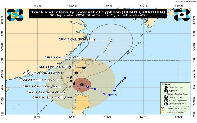
At 4:00 PM today, the center of Typhoon Julian was located approximately 95 kilometers west-southwest of Itbayat, Batanes. The typhoon continues to strengthen, packing maximum sustained winds of 175 kilometers per hour (km/h) near its center, with gustiness reaching up to 215 km/h. The central pressure is recorded at 940 hPa. Julian is moving west-northwestward at a speed of 15 km/h, carrying strong typhoon-force winds extending outward up to 560 kilometers from its center.
Tropical Cyclone Wind Signals (TCWS) Raised
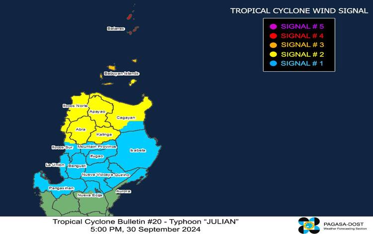
Several Tropical Cyclone Wind Signals (TCWS) remain in effect as Typhoon Julian continues to pose a significant threat to northern Luzon, particularly in Batanes and Babuyan Islands.
- TCWS No. 4: Batanes remain under TCWS No. 4, experiencing typhoon-force winds with speeds ranging from 118 to 184 km/h. PAGASA warns of significant to severe threats to life and property, with the strongest winds expected to hit this afternoon until evening.
- TCWS No. 3: The northern and western portions of Babuyan Islands are under TCWS No. 3, bracing for storm-force winds between 89 and 117 km/h. This poses moderate to significant risks to life and property.
- TCWS No. 2: Northern portions of mainland Cagayan, Apayao, Abra, Kalinga, Ilocos Norte, and parts of Ilocos Sur are under TCWS No. 2, with gale-force winds expected to impact the area within 24 hours. Wind speeds in these areas will range between 62 to 88 km/h, posing a minor to moderate threat to life and property.
- TCWS No. 1: Regions including parts of Ilocos Sur, La Union, Pangasinan, Ifugao, Mountain Province, Benguet, Isabela, and portions of Aurora and Nueva Ecija are under TCWS No. 1, with strong winds between 39 to 61 km/h anticipated.
Hazardous Winds and Heavy Rainfall Outlook
PAGASA warns of severe winds and potentially devastating impacts in areas under TCWS No. 4. Winds in these areas are expected to peak this afternoon and continue into the evening. Storm-force winds will cause moderate to significant impacts in localities under TCWS No. 3, while gale-force winds will be felt in regions under TCWS No. 2.
Additionally, areas outside the direct path of Typhoon Julian may still experience gusty conditions due to the enhanced wind flow from the typhoon’s circulation. These include parts of Aurora, Zambales, Bataan, Metro Manila, CALABARZON, Romblon, and the Bicol Region.
Residents in these areas are urged to remain vigilant, as strong to gale-force gusts may persist today and tomorrow, October 1, particularly in coastal and mountainous areas.
Coastal Inundation and Storm Surge Warning
PAGASA has also issued a storm surge warning for low-lying coastal areas in Batanes, Cagayan, and Ilocos Norte. A moderate to high risk of life-threatening storm surge is expected within the next 48 hours, particularly in exposed coastal areas. Mariners are advised to take precautions, as sea conditions remain extremely hazardous, with wave heights reaching up to 14 meters in Batanes and 10 meters in Babuyan Islands.
Track and Forecast
Typhoon Julian is forecast to move westward to northwestward over the Bashi Channel before beginning a slow curvature on October 1, steering northeastward toward the southwestern coast of Taiwan. A landfall over Taiwan is expected by October 2, after which the typhoon will weaken due to interaction with Taiwan’s rugged terrain. Julian is expected to exit the PAR by October 3 as it moves toward the East China Sea.
PAGASA continues to monitor the typhoon closely and will issue the next update at 11:00 PM tonight. Residents are urged to stay informed through official channels and take necessary precautions.