Super Typhoon “Julian” (international name: KRATHON) continues to maintain its strength as it begins to recurve towards the North-Northwest. As of 4:00 PM today, the eye of the storm was located 245 kilometers west of Itbayat, Batanes. It remains a powerful system, with maximum sustained winds reaching 195 km/h near the center, gusts up to 240 km/h, and a central pressure of 915 hPa.
Current Movement and Intensity
Julian is currently moving slowly in a north-northwestward direction. Strong typhoon-force winds extend outward up to 560 km from the center, impacting a broad area. The extent of these winds highlights the storm’s wide-reaching influence, especially as it continues to track through the northern seas.
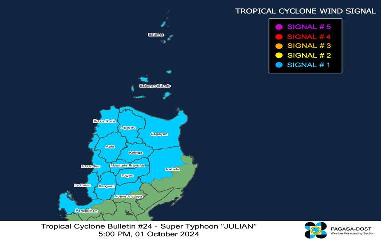
Tropical Cyclone Wind Signals (TCWS) in Effect
TCWS No. 1 remains hoisted over parts of Luzon, indicating the threat of strong winds within the next 36 hours. The wind speeds in areas under this signal range from 39 to 61 km/h, posing minimal to minor threats to life and property. These areas include:
Luzon:
- Ilocos Norte, Ilocos Sur, La Union, and portions of Pangasinan
- Apayao, Abra, Kalinga, Mountain Province, Ifugao, and Benguet
- Batanes, Cagayan including Babuyan Islands, parts of Isabela, and Nueva Vizcaya
Potential Hazards Over Land
Heavy Rainfall Outlook
The latest Weather Advisory No. 24 issued at 5:00 PM today outlines the heavy rainfall outlook due to Super Typhoon Julian. These rains may trigger flooding and landslides, especially in vulnerable areas across Northern and Central Luzon. Residents are advised to monitor local weather updates closely.
Severe Winds
Areas under TCWS No. 1 may experience winds strong enough to cause minor damage, particularly in coastal and mountainous regions. Localized strong to gale-force winds are likely over the following regions:
- Today (October 1): Ilocos Region, Cordillera Administrative Region, northern and eastern portions of Cagayan, Isabela, and Zambales
- Tomorrow (October 2): Ilocos Norte, Ilocos Sur, Abra, Apayao, Batanes, Babuyan Islands, and Cagayan
- Thursday (October 3): Batanes and Babuyan Islands
Coastal Waters and Gale Warnings
A Gale Warning remains in effect over the northern seaboard of Northern Luzon due to the intense winds generated by Julian. Very rough sea conditions, with waves reaching up to 6.0 meters, are expected in the seaboards of Batanes, and up to 4.5 meters along the coastlines of Babuyan Islands and Ilocos Norte. Mariners are advised to avoid sea travel, especially smaller vessels and motorbancas, as these waters are perilous under current conditions.
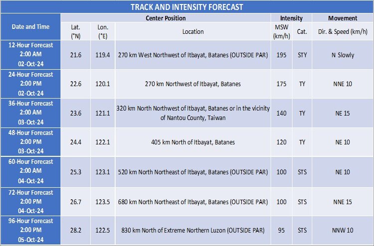
Track and Intensity Outlook
Julian is forecast to recurve towards the sea southwest of Taiwan by tomorrow morning. It is expected to make landfall along Taiwan’s southwestern coast by the afternoon of October 2, crossing the island’s rugged terrain before emerging over the sea east of Taiwan by Thursday, October 3. The typhoon is projected to exit the Philippine Area of Responsibility by Thursday evening or early Friday morning, moving towards the East China Sea.
The storm has a brief window for intensification in the next 12 hours before it interacts with the mountainous regions of Taiwan, which is expected to weaken it slightly. By Thursday afternoon or evening, Julian will likely downgrade into a severe tropical storm.