The Philippine Atmospheric, Geophysical, and Astronomical Services Administration (PAGASA) has provided its latest update on Tropical Storm “Kristine,” which continues to intensify as it moves over the Philippine Sea east of the Bicol Region.
Current Location and Intensity
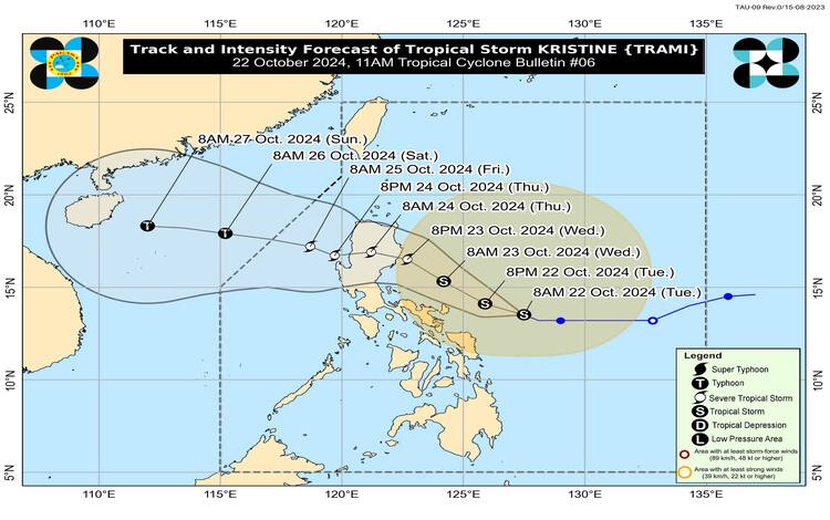
As of 10:00 AM, Typhoon Kristine was located approximately 335 kilometers east of Virac, Catanduanes, with its center at 13.7°N, 127.3°E. The storm is maintaining its strength with maximum sustained winds of 65 kilometers per hour (km/h) near the center and gusts of up to 80 km/h. Its central pressure remains at 994 hPa. Currently, Kristine is moving west-northwestward at a speed of 10 km/h, posing a potential threat to the eastern regions of Luzon.
Strong to gale-force winds are extending outwards up to 720 kilometers from the storm’s center, affecting large parts of Luzon, Visayas, and Mindanao.
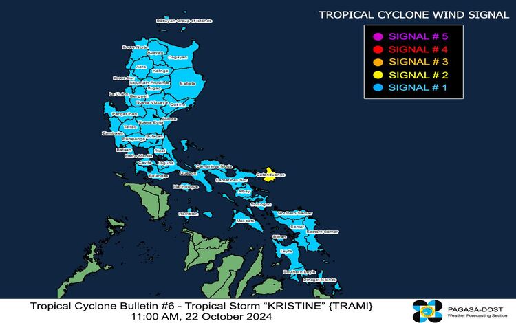
Tropical Cyclone Wind Signals (TCWS) in Effect
PAGASA has raised various wind signals across affected areas. Currently, TCWS No. 2 and TCWS No. 1 are in effect.
- TCWS No. 2 is hoisted over Catanduanes in Luzon, where wind speeds ranging from 62 to 88 km/h are expected within 24 hours. This signal warns of a moderate threat to life and property due to strong winds.
- TCWS No. 1 is in effect across a wide area, including parts of Luzon, Visayas, and Mindanao. Provinces affected by this signal include Ilocos Norte, Ilocos Sur, La Union, Pangasinan, Cagayan, Isabela, Aurora, and many more. Winds of 39 to 61 km/h are expected within the next 36 hours, posing minimal to minor threats to life and property.
Rainfall and Wind Outlook
PAGASA has issued Weather Advisory No. 7 at 11:00 AM today, detailing the heavy rainfall outlook due to Kristine. Strong to gale-force winds may occur, especially in coastal and mountainous areas, while minor to moderate impacts from gale-force winds are expected in areas under TCWS No. 2. In regions under TCWS No. 1, minimal to minor impacts from strong winds are anticipated.
Areas at risk of strong winds today (October 22) include Batanes, Babuyan Islands, Ilocos Region, Palawan, Romblon, and parts of Central Visayas. By tomorrow, October 23, these winds will likely affect MIMAROPA, Visayas, and Mindanao. On October 24, the wind threat expands further, potentially impacting regions like Bicol, Basilan, Sulu, Tawi-Tawi, and parts of Northern Mindanao and Davao.
Coastal Hazards and Gale Warnings
Kristine is also expected to cause significant coastal hazards. PAGASA has issued a Gale Warning over the eastern seaboard of Luzon, the southern seaboard of Southern Luzon, and the eastern seaboard of Visayas. This includes Catanduanes, Camarines Norte, Aurora, Isabela, and other provinces where sea conditions will be dangerous for all types of sea vessels.
- High seas of up to 7.0 meters are expected in the seaboards of Batanes, Cagayan, and Babuyan Islands, while Aurora and Ilocos Norte could experience waves as high as 6.0 meters. Travel over these seas is highly discouraged, and mariners are advised to remain in port or seek immediate shelter until conditions improve.
- Very rough seas (up to 5.0 meters) will affect the eastern seaboards of Albay, Sorsogon, and Northern Samar, while rough seas (up to 4.0 meters) are forecast over the seaboard of Zambales and parts of Eastern Samar. Smaller vessels and motorbancas should avoid venturing out to sea.
Coastal Inundation
PAGASA has also issued a Storm Surge Warning over low-lying coastal areas in Catanduanes, Camarines Sur, Albay, Aurora, Isabela, and Cagayan. The risk of life-threatening storm surges is moderate to high in the next 48 hours, with residents in these areas advised to take precautions.
Track and Intensity Outlook
Kristine is expected to continue moving west-northwestward over the next 24 to 36 hours, with landfall projected over Isabela or northern Aurora by tomorrow evening (October 23) or early Thursday morning (October 24). After crossing the rugged terrain of Northern Luzon, Kristine will likely weaken slightly before re-emerging over the West Philippine Sea, where it may intensify into a typhoon before exiting the Philippine Area of Responsibility (PAR) on Friday, October 25.
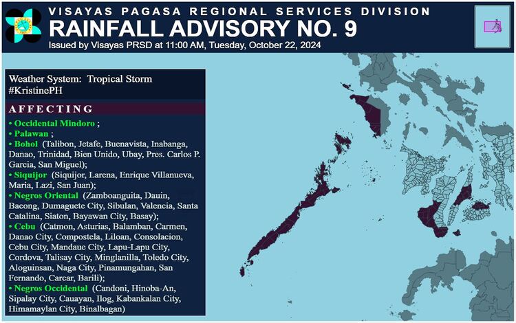
Heavy Rainfall Advisory
Meanwhile, parts of Occidental Mindoro, Palawan, Bohol, Siquijor, Negros Oriental, Cebu, and Negros Occidental are experiencing light to moderate rains with occasional heavy downpours. These conditions are expected to persist for the next 2 to 3 hours and could lead to flooding and landslides in susceptible areas.
Residents in affected areas are advised to monitor further updates from PAGASA and take necessary precautions, especially in flood-prone and landslide-prone areas.