Issued at 11:00 AM on 24 October 2024, the Philippine Atmospheric, Geophysical, and Astronomical Services Administration (PAGASA) has released its latest bulletin on Severe Tropical Storm Kristine (international name: Trami), which continues to move over the Cordillera Administrative Region. As of 10:00 AM, the storm’s center was located near Bauko, Mountain Province, with maximum sustained winds of 95 km/h near the center and gusts reaching up to 160 km/h. The central pressure was recorded at 985 hPa, and Kristine is moving west-southwestward at 20 km/h. The storm’s powerful winds extend outward up to 730 kilometers from the center, affecting large areas across Luzon.
Tropical Cyclone Wind Signals (TCWS)
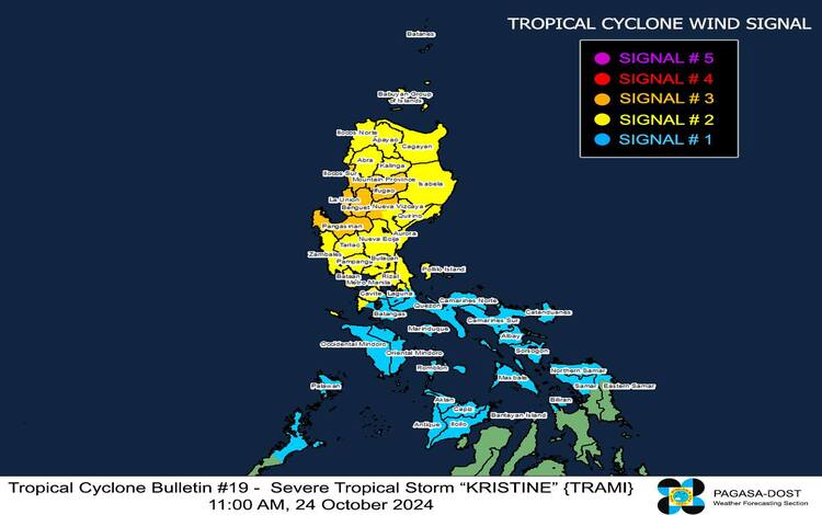
PAGASA has raised several Tropical Cyclone Wind Signals (TCWS) across different regions in Luzon as Typhoon Kristine continues its approach. The following wind signals are in effect:
- TCWS No. 3: Storm-force winds ranging from 89 to 117 km/h pose moderate to significant threats to life and property. This warning covers Mountain Province, Ifugao, Benguet, parts of Nueva Vizcaya, southern Ilocos Sur, La Union, and Pangasinan. Residents in these areas should prepare for potentially damaging winds and impacts.
- TCWS No. 2: Gale-force winds (62 to 88 km/h) are expected to bring minor to moderate threats to life and property in areas such as Cagayan, Isabela, Quirino, Apayao, Kalinga, Abra, Ilocos Norte, Nueva Ecija, Aurora, Bulacan, and parts of Metro Manila, among others. Residents in these areas should remain vigilant.
- TCWS No. 1: Strong winds (39 to 61 km/h) may bring minimal to minor threats to life and property in areas including Batanes, Quezon, Batangas, Occidental and Oriental Mindoro, Marinduque, Romblon, northern Palawan, and parts of Visayas such as Aklan, Capiz, Iloilo, and Samar.
Heavy Rainfall and Severe Winds Outlook
PAGASA advises the public to stay updated with Weather Advisory No. 20 for the expected heavy rainfall brought by Kristine. The storm is expected to produce moderate to significant impacts from storm-force winds in areas under TCWS No. 3. In contrast, gale-force winds may affect localities under TCWS No. 2. Coastal and upland areas should brace for stronger winds, particularly in regions exposed to the storm’s path.
For today (24 October), areas such as MIMAROPA, the Bicol Region, Visayas, Basilan, Sulu, Tawi-Tawi, and parts of Mindanao are expected to experience strong to gale-force gusts. Similar conditions may prevail tomorrow (25 October) and Saturday (26 October), especially in coastal and elevated areas.
Coastal Inundation and Sea Conditions
A minimal to moderate risk of storm surge, up to 2 meters above normal tide levels, is expected in low-lying coastal areas of Ilocos Norte, Ilocos Sur, La Union, Pangasinan, Cagayan, Isabela, Aurora, and Zambales. The public is advised to take precautions and monitor further storm surge warnings.
Sea travel is deemed extremely risky across multiple seaboards, with wave heights reaching up to 8 meters in parts of the Ilocos Region and Zambales. Gale warnings have been raised, and mariners are strongly urged to remain in port or seek shelter until conditions improve.
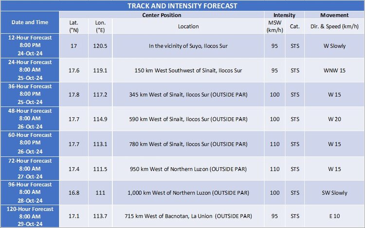
Track and Intensity Outlook
Severe Tropical Storm Kristine is forecast to exit the landmass of Luzon by this afternoon, moving west-northwestward over the West Philippine Sea. The storm may weaken slightly due to its interaction with land, though it may re-intensify upon reaching open waters. Kristine will exit the Philippine Area of Responsibility by tomorrow, 25 October.