Issued at 11:00 AM, 25 October 2024
Valid for broadcast until the next bulletin at 5:00 PM today.
The latest update from the Philippine Atmospheric, Geophysical, and Astronomical Services Administration (Pagasa) indicates that Severe Tropical Storm “Kristine” (International name: Trami) is on the verge of exiting the Philippine Area of Responsibility (PAR). As of 10:00 AM today, the center of the storm was located approximately 255 km west-northwest of Bacnotan, La Union, or 255 km west-southwest of Sinait, Ilocos Sur, with coordinates at 17.4°N and 118.1°E.
Current Intensity and Movement
Kristine currently carries maximum sustained winds of 95 km/h near its center, with gustiness reaching up to 115 km/h. The central pressure is measured at 985 hPa. The storm continues to move west-northwestward at a speed of 15 km/h, heading further away from the Philippines.
The extent of tropical cyclone winds reaches up to 730 km from the storm’s center, affecting wide areas across Luzon and parts of the Visayas.
Tropical Cyclone Wind Signals (TCWS) in Effect
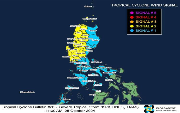
TCWS No. 2
- Wind Threat: Gale-force winds
- Warning Lead Time: 24 hours
- Wind Speeds: 62-88 km/h
- Potential Impacts: Minor to moderate threats to life and property
Affected areas in Luzon: Northwestern Cagayan (Santa Praxedes, Claveria, Sanchez-Mira, Abulug, Pamplona), Babuyan Islands, Nueva Vizcaya, Apayao, Abra, Kalinga, Mountain Province, Ifugao, Benguet, Ilocos Norte, Ilocos Sur, La Union, Pangasinan, Nueva Ecija, Tarlac, Pampanga, Zambales, and the northern portion of Bataan (Morong, Hermosa, Dinalupihan, Bagac, Orani, Samal, Abucay, City of Balanga).
TCWS No. 1
- Wind Threat: Strong winds
- Warning Lead Time: 36 hours
- Wind Speeds: 39-61 km/h
- Potential Impacts: Minimal to minor threats to life and property
Affected areas in Luzon: Batanes, the rest of mainland Cagayan, Isabela, Quirino, Aurora, Bulacan, the rest of Bataan, Metro Manila, Cavite, Batangas, Laguna, Rizal, Quezon, Occidental Mindoro, Oriental Mindoro, Marinduque, Romblon, northern Palawan (El Nido, Taytay, San Vicente, Dumaran, Araceli), Calamian, Cuyo, and Kalayaan Islands, Camarines Norte, Camarines Sur, and Burias Island.
Affected areas in the Visayas: Northern Aklan (Buruanga, Malay, Nabas, Ibajay), and northern Antique (Libertad, Pandan), including Caluya Islands.
Other Hazards Affecting Land Areas
Heavy Rainfall Outlook
According to Weather Advisory No. 27 issued today at 11:00 AM, heavy rainfall is expected in areas under Wind Signal No. 2 and Signal No. 1.
Severe Winds
Gale-force winds may bring minor to moderate impacts in areas under Signal No. 2, while areas under Signal No. 1 could experience minimal to minor impacts from strong winds. Coastal and upland areas exposed to winds could feel enhanced effects due to the interaction of northeasterly and southwesterly windflows.

Coastal Inundation
There is a minimal to moderate risk of storm surge over the next 48 hours in low-lying coastal localities of Ilocos Sur, La Union, Pangasinan, and Zambales, with peak heights of 1.0 to 2.0 meters above normal tide levels.
Sea Conditions and Gale Warning
Pagasa has issued a Gale Warning for the seaboards of Luzon and the western seaboard of Visayas, advising that sea travel is risky due to rough to very rough seas. Mariners are urged to remain in port or seek shelter until conditions improve.
24-Hour Sea Condition Outlook
- Very Rough Seas (Up to 6.0 m): Western seaboard of Pangasinan, Zambales, and Bataan.
- Rough to Very Rough Seas (Up to 5.5 m): Remaining seaboard of Pangasinan, and seaboards of Batanes, Babuyan Islands, and La Union.
- Mariners of small seacrafts, including motorbancas, are advised to avoid sea travel, especially in these conditions.
Track and Intensity Outlook
Kristine is expected to exit the PAR later today. While it may intensify further as it moves over the West Philippine Sea, the storm is predicted to maintain its classification as a severe tropical storm for the next five days, though the chance of it being upgraded to a typhoon is not ruled out. A weakening trend may begin early next week due to a surge of northeasterly winds.
Pagasa continues to monitor Kristine and will provide updates in the next bulletin at 5:00 PM. The public is advised to stay alert and heed warnings from local authorities, especially in areas under Wind Signals or those at risk of coastal inundation.