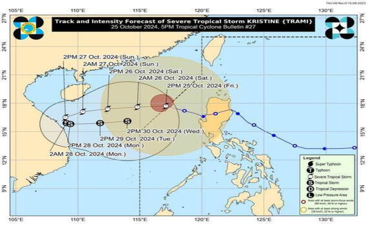
Severe Tropical Storm “Kristine” (international name: Trami) has accelerated outside the Philippine Area of Responsibility (PAR), continuing its path west-northwestward over the West Philippine Sea. As of 4:00 PM, “Kristine” was located approximately 410 km west of Sinait, Ilocos Sur, with maximum sustained winds of 95 km/h, gustiness reaching up to 115 km/h, and a central pressure of 985 hPa. The storm is moving west-northwest at a speed of 30 km/h, with its strong winds extending up to 580 km from the center.
Current Advisories and Warnings
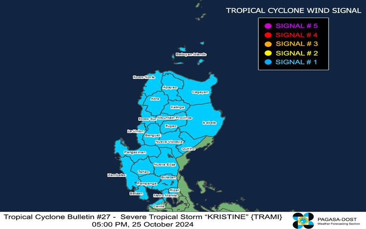
Tropical Cyclone Wind Signal No. 1 remains in effect for parts of Luzon, where winds ranging from 39 to 61 km/h (Beaufort scale 6-7) are anticipated. While impacts on life and property are expected to be minimal to minor, residents in these areas are advised to stay vigilant, particularly in coastal and mountainous regions that may experience enhanced winds due to the cyclone’s influence. Areas affected include Ilocos Norte, Ilocos Sur, La Union, Pangasinan, Apayao, Kalinga, Abra, Mountain Province, Ifugao, Benguet, parts of Metro Manila, northern Rizal, and northern Cavite, among others.
Rainfall and Wind Impacts
Although “Kristine” is situated outside PAR, its interaction with the southwesterly wind flow will result in significant rainfall and strong gusts across various regions. Heavy rains and strong to gale-force winds are expected in several areas across the Philippines:
- October 25: MIMAROPA, Bicol Region, Visayas, Dinagat Islands, Surigao del Norte, Northern Mindanao, Zamboanga Peninsula, BARMM, SOCCSKSARGEN, and Davao Region.
- October 26: Palawan, Romblon, Western Visayas, Negros Island Region, Siquijor, Bohol, Southern Leyte, Zamboanga del Norte, Camiguin, Dinagat Islands, and Surigao del Norte.
- October 27: Palawan, Romblon, Visayas, Zamboanga del Norte, Camiguin, Dinagat Islands, and Surigao del Norte.
Residents in these areas should be prepared for flash floods and landslides, especially in low-lying areas and near rivers. Meanwhile, the southwesterly wind flow influenced by Tropical Storm Kong-Rey, situated outside PAR, will further enhance wind gusts in coastal and upland areas, especially those facing westward.
Marine Warnings
All Storm Surge Warnings have been lifted for the affected coastal areas. However, Gale Warnings remain in effect over the northern and western seaboards of Luzon, where wave heights are projected to reach between 4.0 and 6.0 meters, especially in areas such as Pangasinan, Zambales, and Bataan. Mariners and all types of vessels, especially small crafts and motorbancas, are advised to remain in port or seek safe harbor until conditions improve.
The detailed sea condition forecast over the next 24 hours indicates that very rough to high seas are expected along the western coasts of Luzon, with wave heights potentially reaching 6.0 meters. In areas around MIMAROPA, Visayas, and selected parts of Mindanao, waves could range from 2.5 to 4.0 meters, posing a significant risk for small vessels.
Track and Intensity Outlook
Severe Tropical Storm “Kristine” is projected to continue its westward movement in the West Philippine Sea. By Sunday, it is expected to loop counterclockwise before taking an eastward direction due to interacting weather systems around the West Philippine Sea. “Kristine” is likely to intensify slightly in the next two days, though it is forecasted to maintain severe tropical storm strength for now. By early next week, however, the storm may weaken as it encounters a surge of northeasterly wind flow over the sea.