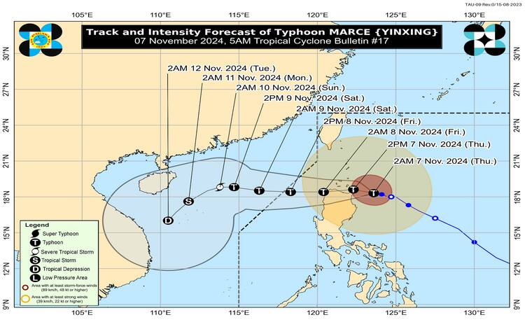
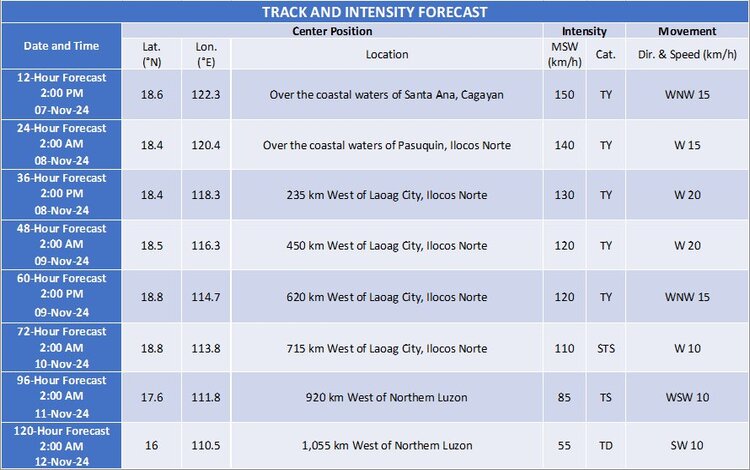
Typhoon Marce continues its approach toward Northern Luzon, posing a significant threat to the Cagayan-Babuyan Islands region. With maximum sustained winds of 155 km/h and gusts reaching up to 190 km/h, Marce’s center was located approximately 200 kilometers east of Aparri, Cagayan, moving west-northwest at a speed of 15 km/h. This powerful storm brings with it an extensive wind field, stretching up to 560 kilometers from its center.

Tropical Cyclone Wind Signals
The Philippine Atmospheric, Geophysical, and Astronomical Services Administration (PAGASA) has raised multiple Tropical Cyclone Wind Signals (TCWS) over parts of Luzon due to the anticipated effects of Typhoon Marce:
- TCWS No. 4: Covers the northern portion of mainland Cagayan (including Aparri, Santa Ana, and other nearby towns), Babuyan Islands, and the northeastern part of Apayao. Residents here should expect storm-force winds within the next 12 hours, posing severe threats to life and property.
- TCWS No. 3: This includes the southern part of Batanes, the rest of Cagayan, Apayao, Ilocos Norte, and the northern portion of Abra. Within 18 hours, these areas will experience storm-force winds, creating moderate to significant threats to safety and infrastructure.
- TCWS No. 2: Issued for the rest of Batanes, northern and central Isabela, Abra, Kalinga, Mountain Province, and parts of Ilocos Sur and La Union. Gale-force winds are expected within 24 hours, bringing minor to moderate threats.
- TCWS No. 1: Covers the rest of La Union, Pangasinan, and portions of Ifugao, Benguet, Isabela, Quirino, Nueva Vizcaya, Aurora, Nueva Ecija, and Zambales. These regions may see strong winds within 36 hours, with minimal to minor expected impacts.
Heavy Rainfall and Severe Winds
Heavy rains are anticipated in the areas directly affected by Marce’s wind field. Coastal areas, especially those exposed to the windward side, are likely to see stronger gusts. PAGASA warns of potentially severe impacts from typhoon-force winds in areas under TCWS No. 4, while moderate to significant damage is expected in areas under TCWS No. 3.
Coastal and Sea Condition Outlook
A high risk of storm surge threatens low-lying coastal communities in Batanes, Cagayan (including the Babuyan Islands), Isabela, Ilocos Norte, Ilocos Sur, and La Union. Storm surge heights may reach over 3 meters above normal tide levels, posing life-threatening risks. PAGASA has issued a Gale Warning, advising mariners of all vessel sizes to avoid sea travel due to rough to very rough seas across the seaboards of Northern and Central Luzon.
- Sea Conditions: Seas around Babuyan Islands may reach up to 12 meters, while waters off northern Cagayan and Ilocos Norte may see waves as high as 9 meters. Moderate seas are expected along the eastern seaboards of Luzon and Visayas, with wave heights reaching up to 2.5 meters.
Projected Track and Intensity
Typhoon Marce is expected to continue on a west-northwest trajectory, nearing Northern Cagayan by this afternoon. It is forecasted to make landfall or pass close to the Babuyan Islands and northern portions of Cagayan, Ilocos Norte, and Apayao between this afternoon and early morning tomorrow. Marce may exit the Philippine Area of Responsibility (PAR) by tomorrow evening as it slightly weakens, influenced by the rugged terrain of Northern Luzon and an incoming surge of northeasterly winds.

Safety Reminders and Next Bulletin
Residents in affected areas should heed local warnings, prepare for possible evacuations, and take precautions against flash floods, landslides, and hazardous winds. PAGASA advises the public to stay updated with further bulletins, especially as Typhoon Marce approaches land. The next bulletin will be issued at 8:00 AM.
