Typhoon Marce (international name Yinxing) has weakened slightly but remains a significant threat to areas in Northern Luzon as it moves west-northwest over the sea west of Ilocos Norte. As of 4:00 AM today, the center of Marce was positioned near the coastal waters of Pasuquin, Ilocos Norte, with maximum sustained winds of 155 km/h, gustiness up to 215 km/h, and a central pressure of 955 hPa. The typhoon is moving west-northwestward at a speed of 10 km/h and is expected to continue weakening gradually as it progresses.

Tropical Cyclone Wind Signals
The Philippine Atmospheric, Geophysical, and Astronomical Services Administration (PAGASA) has placed several areas under various Tropical Cyclone Wind Signals (TCWS) due to the threat posed by Marce’s powerful winds.
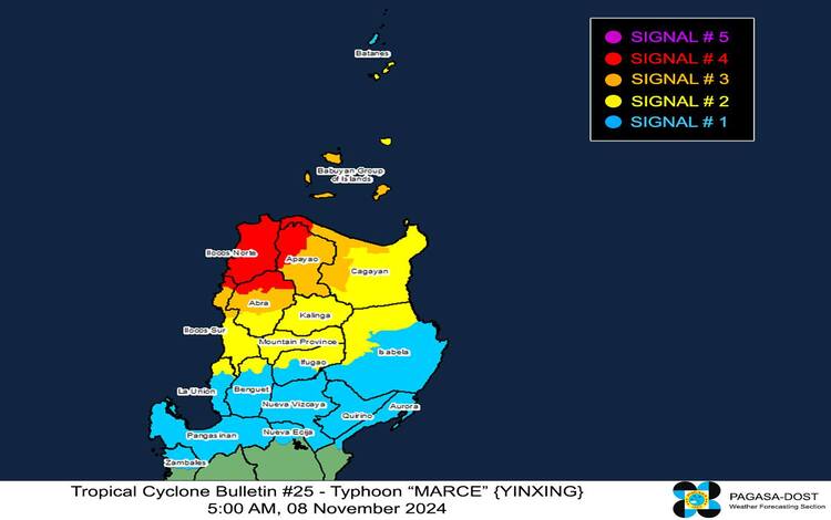
- TCWS No. 4 (Typhoon-force winds): Residents of Ilocos Norte, northern Ilocos Sur, the northern portion of Abra, northwestern Apayao, and the northwestern part of mainland Cagayan should brace for potentially life-threatening winds. These areas could experience winds ranging from 118 to 184 km/h within 12 hours, with severe damage to life and property possible.
- TCWS No. 3 (Storm-force winds): The southern and western parts of the Babuyan Islands, parts of central Cagayan, northern Ilocos Sur, and central Abra are under this signal. Winds in these areas may reach 89-117 km/h over the next 18 hours, presenting a significant risk to property and personal safety.
- TCWS No. 2 (Gale-force winds): Southern Batanes, remaining Babuyan Islands, parts of mainland Cagayan, and sections of Isabela and the Cordilleras, including Mountain Province, Ifugao, and parts of Benguet, are under Signal No. 2, where wind speeds are expected to range from 62-88 km/h within 24 hours.
- TCWS No. 1 (Strong winds): Other areas in Northern Luzon, including the rest of Batanes, La Union, and sections of Aurora and Nueva Ecija, are under this signal, with expected winds of 39-61 km/h. While the wind impact here is minimal to minor, caution is still advised, especially for coastal and mountainous regions.
Heavy Rainfall and Coastal Threats
PAGASA has also issued warnings for potential heavy rainfall and coastal hazards associated with Typhoon Marce:
- Heavy Rainfall: Due to Marce’s expansive cloud cover and intense rain bands, Northern Luzon, including Ilocos Norte, Ilocos Sur, and parts of the Cordillera region, will likely experience heavy rains throughout the day. PAGASA advises residents to monitor Weather Advisory No. 22 for detailed rainfall forecasts and localized flood risk warnings. Flooding and landslides remain concerns, especially in low-lying and mountainous areas.
- Coastal Inundation: A high risk of life-threatening storm surge persists in areas along the coastal regions of Batanes, Cagayan, Babuyan Islands, Ilocos Norte, Ilocos Sur, and La Union. PAGASA warns that surge heights could exceed 3.0 meters over the next 48 hours, posing severe threats to residents in these low-lying areas. Residents should heed evacuation orders and seek higher ground as advised by local officials.
Severe Wind Impacts
The severe wind impacts of Marce are most pronounced in areas under TCWS Nos. 3 and 4, where typhoon-force and storm-force winds may cause widespread damage:
- Typhoon-force winds (TCWS No. 4) can bring down trees, and power lines, and potentially cause structural damage to buildings.
- Storm-force winds (TCWS No. 3) may also lead to property damage, especially to lightweight structures, and hinder outdoor mobility.
Local authorities have activated emergency measures to assist affected residents and ensure timely evacuations where necessary. The public is strongly advised to stay indoors and avoid unnecessary travel as Marce’s strong winds continue.
Sea Condition Warnings
Given Marce’s ongoing strength and expansive wind field, sea conditions around Northern Luzon are extremely dangerous for maritime activities:
- Very Rough Seas (up to 12.0 meters): The seaboards of Babuyan Islands and Ilocos Norte are expected to experience waves as high as 12.0 meters, with rough seas extending to other coastal waters surrounding Ilocos Region and Batanes.
- Rough to Very Rough Seas (3.0 to 8.0 meters): Coastal waters around Ilocos Sur, Cagayan, and the rest of Batanes will also be hazardous for maritime operations.
PAGASA has issued Gale Warnings for these areas, urging all vessels to stay in port until conditions improve. Mariners are advised to exercise extreme caution, especially small craft operators who may face life-threatening conditions if they venture out to sea.
Track and Intensity Forecast
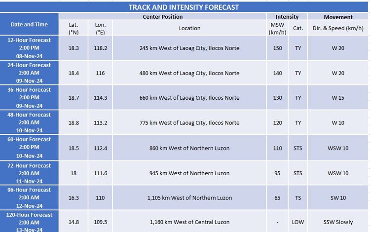
Marce is forecast to continue moving westward and may exit the Philippine Area of Responsibility (PAR) later today or by tonight. By Sunday, November 10, the typhoon is expected to be influenced by a surge of northeasterly winds, leading to a shift towards the southwest. Marce is likely to weaken further as it progresses due to dry air from the northeast monsoon but will retain its typhoon status until it exits PAR.

Preparedness and Advisories
Residents are urged to remain vigilant and closely monitor PAGASA and local government unit updates. Preparedness is crucial, especially for those in areas under higher wind signals. PAGASA’s next advisory on Marce will be released at 8:00 AM today, and further details on rainfall and storm surge risk will continue to be updated.
Stay tuned to official channels for the latest information on Typhoon Marce as it progresses westward across the waters off Ilocos Norte.
