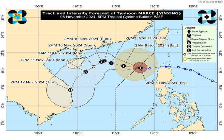
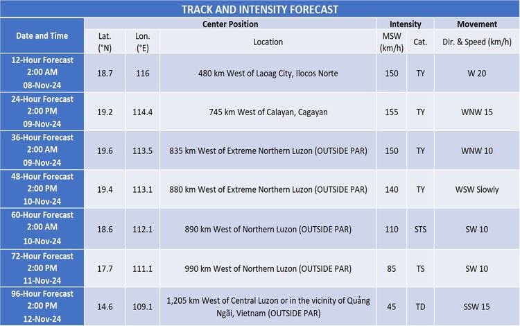
November 8, 2024 – The Philippine Atmospheric, Geophysical and Astronomical Services Administration (PAGASA) has reported that Typhoon “Marce” (international name: Yinxing) has exited the Philippine Area of Responsibility (PAR). As of 10:00 AM today, the typhoon’s eye was located at 18.4°N latitude and 117.8°E longitude. Marce carries maximum sustained winds of 150 km/h near the center and gusts reaching up to 185 km/h, with a central pressure of 960 hPa. The typhoon is moving west-southwest at 20 km/h.

While Marce has moved away from the Philippines, its broad wind field, extending up to 400 kilometers from the center, continues to influence nearby areas. Currently, no Tropical Cyclone Wind Signals (TCWS) are in effect, indicating that direct impacts from Marce’s strong winds have diminished. However, localized severe weather, including strong to gale-force gusts, is still expected in several northern regions due to the combined effects of Marce’s periphery and the prevailing northeasterly wind flow.
Ongoing Weather Hazards
Severe Winds
The northeasterly wind flow, combined with Marce’s influence, will bring strong to gale-force gusts today over Batanes, northern Cagayan (including the Babuyan Islands), and parts of the Ilocos Region, especially in coastal and highland areas. Residents in these locations are advised to prepare for potentially hazardous wind conditions that may impact lightweight structures and cause minor damage to trees and utility lines.
Coastal Inundation and Storm Surge
PAGASA has lifted all storm surge warnings as the threat of coastal inundation from Typhoon Marce has ceased. A final Storm Surge Warning was issued at 2:00 PM today, concluding any immediate threat of storm surge in the affected coastal regions.
Gale Warning and Sea Conditions
A Gale Warning remains in effect along the western seaboard of Northern Luzon, particularly impacting Ilocos Norte and Ilocos Sur. The coastal waters in this region may experience very rough seas, with waves reaching heights of up to 4.5 meters. PAGASA cautions that sea travel is risky for all vessel types in these areas. Mariners are advised to stay in port or seek immediate shelter if already underway, as high winds and strong waves create hazardous conditions.
The following is the detailed sea condition forecast for various regions:
- Very Rough Seas (up to 4.5 m): The western seaboards of Ilocos Norte and Ilocos Sur.
- Rough Seas (up to 4.0 m): The seaboards of Zambales and the western seaboards of Batanes, Babuyan Islands, and the Ilocos Region.
- Moderate to Rough Seas (up to 3.5 m): Additional seaboards of Batanes, Babuyan Islands, and northern Cagayan.
- Moderate Seas (up to 2.5 m): The seaboard of northern Aurora and the western seaboards of Bataan, Lubang Islands, Calamian Islands, and mainland Palawan.
Small vessels, especially motorized bancas, are advised to avoid navigating in these conditions, as their lightweight builds make them particularly vulnerable to the strong winds and rough seas.
Track and Intensity Outlook
PAGASA projects that Typhoon Marce will continue moving generally westward to west-northwestward over the West Philippine Sea through tomorrow, November 9. By Sunday, November 10, Marce is expected to shift direction to a southwestward path due to the increased influence of the northeasterly wind flow. A brief period of re-intensification is anticipated within the next 24 hours, followed by a gradual weakening as Marce encounters a less favorable environment.

Public Advisory
While Marce has exited PAR, the public and disaster management authorities are encouraged to stay alert for further weather updates and warnings, particularly regarding gale-force winds and hazardous sea conditions that remain in place over parts of Northern Luzon. Individuals in areas prone to wind hazards, especially those near coastal or upland areas, should stay vigilant and heed any advisories from local officials.8
Meanwhile, a new typhoon threat has once again been spotted by PAGASA
For detailed local rainfall, thunderstorms, and other severe weather updates, residents are advised to monitor bulletins from their respective PAGASA Regional Services Division.
