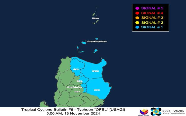
Typhoon “OFEL” (internationally known as USAGI) has strengthened further as it continues its westward path across the Philippine Sea. According to the Philippine Atmospheric, Geophysical and Astronomical Services Administration (PAGASA), as of 4:00 AM today, Typhoon OFEL was located approximately 475 km east-northeast of Virac, Catanduanes, or 595 km east of Daet, Camarines Norte, with coordinates at 14.6°N, 128.5°E.

Intensity and Movement
OFEL has intensified, with maximum sustained winds reaching 120 km/h near its center and gustiness up to 150 km/h. The central pressure is estimated at 970 hPa, indicating its strengthening trend. The typhoon is currently moving westward at a speed of 25 km/h. Its strong winds extend outward up to 300 km from the center, affecting a broad area and posing risks for regions in its projected path.
Tropical Cyclone Wind Signals
PAGASA has raised Tropical Cyclone Wind Signal (TCWS) No. 1 over several areas in Luzon. This signal, which indicates the potential for strong winds within 36 hours, warns of winds ranging from 39 to 61 km/h. Although minimal, these winds may still pose minor threats to life and property in the affected areas, particularly in Cagayan (including the Babuyan Islands), northern and central Isabela, parts of Apayao, eastern Kalinga, and select regions in Mountain Province and Ifugao.
As OFEL moves closer to Luzon, higher wind signals are likely. PAGASA has not ruled out the possibility of hoisting Wind Signal No. 4, especially if the typhoon intensifies further. Coastal and upland areas, especially in Camarines Norte, Camarines Sur, and Catanduanes, will likely experience strong to gale-force gusts today, with the eastern portion of Quezon and the Polillo Islands potentially affected tomorrow.
Heavy Rainfall and Wind Impact
Alongside strong winds, Typhoon OFEL is expected to bring significant rainfall. PAGASA advises referring to Weather Advisory No. 22, issued at 5:00 AM today, for specific rainfall forecasts. Coastal and mountainous areas exposed to winds may face intensified conditions. Wind impacts remain mostly minor under Signal No. 1, though stronger gusts are expected in coastal areas, potentially disrupting local travel and daily activities.
Coastal Inundation and Storm Surge Warning
Typhoon OFEL is also likely to cause moderate to high storm surges in low-lying and exposed coastal areas, with surge heights potentially reaching 2.0 to 3.0 meters. Localities at risk include Batanes, Ilocos Norte, Ilocos Sur, Cagayan, Isabela, and parts of Aurora. These areas are advised to take precautions against coastal flooding, as high-risk storm surge conditions are expected to persist over the next 48 hours.
Sea Conditions and Maritime Advisory
Sea conditions are expected to worsen, with rough seas forecasted along the northern and eastern seaboards of Catanduanes, where waves may reach up to 3.5 meters. Smaller sea vessels, including motorbancas, are strongly advised to avoid navigating these hazardous waters. Moderate seas up to 2.5 meters are also anticipated over the eastern seaboards of Cagayan, Isabela, Aurora, Quezon, Albay, Sorsogon, and other areas. Mariners are urged to take precautionary measures.
Track and Forecast
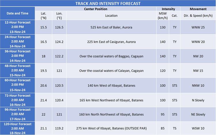
According to PAGASA’s latest forecast, Typhoon OFEL is projected to move west-northwestward to northwestward over the Philippine Sea, potentially making landfall on the east coast of Cagayan or Isabela by tomorrow afternoon (November 14). By Friday (November 15), OFEL may exit over the Luzon Strait, with an expected slowdown and possible erratic movement by the weekend. Two potential tracks have been identified: one that would bring OFEL further south upon landfall, and a recurving track to the right, which would keep the typhoon mainly offshore of Northern Luzon.

Further Advisories
PAGASA emphasizes that even regions outside OFEL’s direct landfall path may experience hazardous conditions due to the typhoon’s extensive wind field and coastal impacts. Continuous monitoring of the storm’s track is advised as changes remain possible within the forecast confidence cone. Residents and local authorities are urged to stay informed on updates and adhere to safety protocols as Typhoon OFEL approaches.
