Severe Tropical Storm “Pepito” (international name MAN-YI) has intensified further and is now approaching typhoon status as it moves across the Philippine Sea. The center of Pepito was last located approximately 795 km east of Guiuan, Eastern Samar, with sustained winds reaching 110 km/h, gusts of up to 135 km/h, and a central pressure of 980 hPa. Currently tracking westward at a steady 25 km/h, Pepito is anticipated to gain strength in the coming hours and is projected to reach typhoon intensity within the next 12 hours.

Wind Signal Alerts and Affected Areas
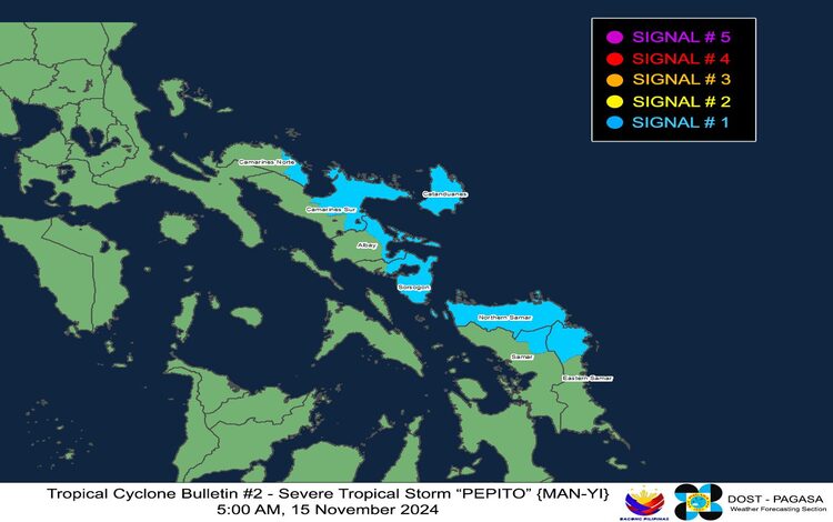
Pagasa has issued Tropical Cyclone Wind Signal No. 1, covering parts of Luzon and the Visayas, indicating a 36-hour lead time for expected strong winds. Signal No. 1 has been raised for the following locations:
- Luzon: Catanduanes, portions of Camarines Norte (e.g., Vinzons, Daet, Basud), Camarines Sur (e.g., Caramoan, Tinambac, Goa), Albay (including Legazpi City and Tabaco), and parts of Sorsogon (e.g., Sorsogon City, Bulusan).
- Visayas: Northern Samar, northeastern areas of Samar (e.g., Matuguinao), and the northern portions of Eastern Samar.
Under Signal No. 1, winds may reach speeds between 39-61 km/h, posing minimal to minor risks to life and property. Coastal and mountainous regions may experience slightly enhanced wind effects, especially in open areas facing the storm’s path.

Hazards on Land and Coastal Areas
Heavy Rainfall
While Pepito’s center is still distant from the mainland, rainfall advisories have been issued. Heavy rains are expected over parts of Luzon and the Visayas as Pepito intensifies. Pagasa warns residents in flood-prone areas and mountainous regions to stay alert for potential flash floods and landslides.
Severe Winds and Coastal Storm Surge
Strong winds are anticipated, especially along the coasts and uplands, where local gustiness may be more pronounced. Pepito may bring a dangerous storm surge of 2.0 to 3.0 meters above normal tide levels, affecting coastal areas in Camarines Sur, Albay, Sorsogon, Northern Samar, and Eastern Samar. A Storm Surge Warning (No. 1) is currently in effect for these areas, and residents in low-lying coastal areas are urged to take precautions and follow evacuation orders if needed.
Sea Condition and Gale Warnings
Pagasa has not issued a gale warning specifically linked to Pepito, but rough to very rough sea conditions remain over several areas due to another weather disturbance, OFEL. Coastal waters over the following regions are expected to be hazardous for navigation:
- Very rough seas (up to 5.0 meters): Batanes, Babuyan Islands, and parts of Cagayan.
- Rough seas (up to 4.0 meters): Isabela, and the northern seaboard of Ilocos Norte.
- Moderate to rough seas (up to 2.5 meters): Catanduanes, Albay, Sorsogon, and Northern Samar’s seaboard.
All mariners are advised to remain in port, avoid sea travel, and take shelter until conditions improve.
Track and Intensity Outlook
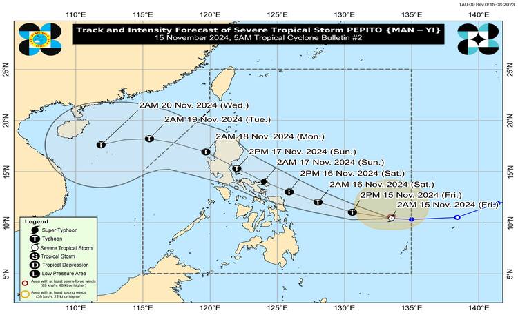
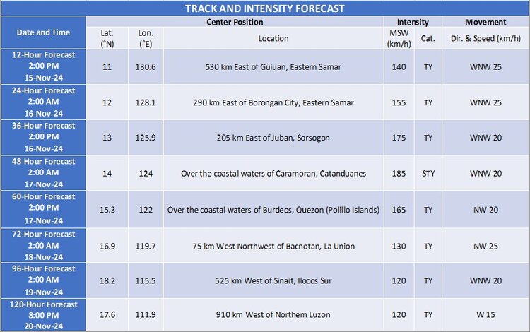
Due to a high-pressure system south of Japan, Pepito is forecasted to maintain its westward trajectory before shifting northwest over the next 12 hours. If this path holds, Pepito is expected to land along the eastern coast of Central or Southern Luzon over the weekend. This tropical cyclone could reach a super typhoon by tomorrow evening, potentially landfall at peak strength. However, gradual weakening is expected as it crosses mainland Luzon, with the storm possibly exiting the Philippine Area of Responsibility (PAR) by Monday, 18 November, in the evening.

Precautionary Measures
Residents in the affected areas, particularly in eastern and southern Luzon, should remain vigilant and prepare for intense weather conditions. Local government units coordinate with disaster response teams to ensure evacuation procedures and resource distribution are ready if conditions worsen.
Pagasa advises the public to stay tuned for updates and follow local authorities’ guidelines regarding safety and preparedness as Pepito continues its course toward the Philippines.
