The Philippine Atmospheric, Geophysical, and Astronomical Services Administration (Pagasa) has announced that Severe Tropical Storm Pepito (international name: MAN-YI) has weakened over the West Philippine Sea.

Current Location and Intensity
As of 10:00 AM today, the center of Pepito was located 270 kilometers west of Batac, Ilocos Norte (18.2°N, 118.0°E). It now carries maximum sustained winds of 110 km/h near the center, gustiness of up to 135 km/h, and a central pressure of 980 hPa. The storm is moving west-northwestward at 20 km/h, with strong storm-force winds extending outward up to 280 km from the center.
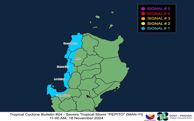
Tropical Cyclone Wind Signal No. 1
Areas affected:
- Ilocos Region: Ilocos Norte, Ilocos Sur, La Union, and the western portion of Pangasinan.
- Abra: Western portion, including towns such as Danglas, Bangued, and Langiden.
Under Signal No. 1, residents may experience winds of 39-61 km/h within the next 36 hours, which could cause minimal to minor threats to life and property.

Hazards Affecting Land and Coastal Areas
Rainfall Outlook:
For rainfall updates, refer to Weather Advisory No. 58 issued at 11:00 AM.
Severe Winds:
Strong winds are expected, particularly in coastal and upland areas, with minor impacts possible in Signal No. 1 areas.
Coastal Inundation:
The threat of storm surge has ceased, with Storm Surge Warning No. 14 declared final.
Sea Conditions:
A Gale Warning remains over the northern seaboard of Northern Luzon. Mariners are advised to stay in port as very rough seas (up to 4.5 meters) are expected on the seaboard of Batanes. Rough sea conditions (up to 4.0 meters) are likely along the seaboards of Ilocos Norte and Babuyan Islands, while moderate seas (up to 2.5 meters) prevail along parts of Cagayan Valley, Aurora, and other seaboards.
Small seacrafts are advised against venturing out to sea under these conditions, particularly if vessels are ill-equipped or inexperienced.
Track and Intensity Outlook
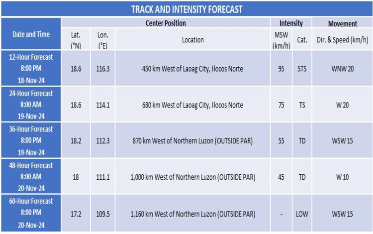
Pepito is expected to continue moving west-northwestward and exit the Philippine Area of Responsibility (PAR) by noon or afternoon today. Upon leaving PAR, it will shift westward or west-southwestward due to an incoming northeasterly wind surge. This surge will create an unfavorable environment, causing further weakening, with Pepito likely becoming a remnant low by Wednesday, November 20.

Public Advisory
Residents in affected areas are advised to stay vigilant, monitor Pagasa updates, and follow directives from local authorities. Mariners should avoid sea travel in hazardous conditions.
Stay tuned for further updates as Pagasa continues to monitor the movement and impact of Severe Tropical Storm Pepito.
