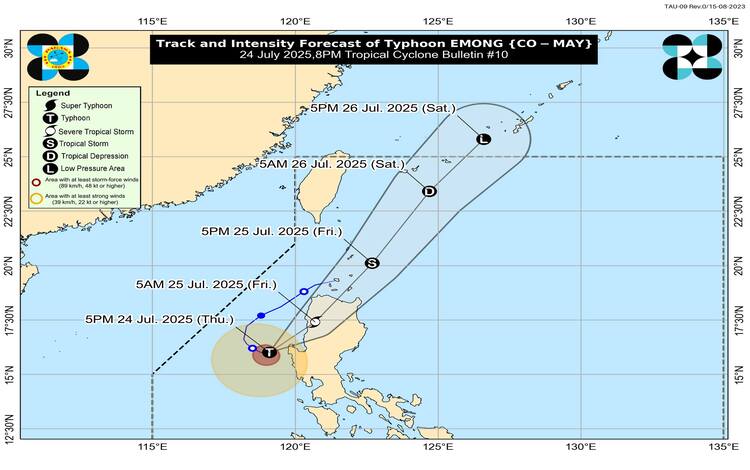
Typhoon Emong (international name Co-may) remains a powerful system as it edges closer to making landfall over the western coast of Pangasinan. As of 7:00 PM, its eye was located off the coast of Burgos, Pangasinan, with maximum sustained winds of 120 km/h near the center, gusts reaching 165 km/h, and a central pressure of 975 hPa.
According to the Philippine Atmospheric, Geophysical and Astronomical Services Administration (PAGASA), Emong is moving slowly eastward and is expected to make landfall within the next few hours. The typhoon’s strong to typhoon-force winds extend up to 240 kilometers from its center, prompting the issuance of multiple Tropical Cyclone Wind Signals (TCWS) across Northern and Central Luzon.
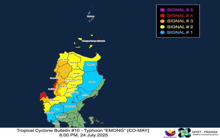
Wind Signals and Potential Impacts
TCWS No. 4, the highest wind alert currently in place, is affecting parts of Ilocos Sur, La Union, and northwestern Pangasinan. These areas face typhoon-force winds that pose a significant to severe threat to life and property.
TCWS No. 3 is raised over more areas in Ilocos Norte, Abra, La Union, Pangasinan, and portions of the Cordillera region, indicating storm-force winds and moderate to significant damage potential.
TCWS Nos. 2 and 1 extend as far as Cagayan, Nueva Vizcaya, Zambales, and Bataan, warning residents of gale-force to strong winds. Localized stronger gusts are expected in coastal and mountainous regions.
Rainfall and Flood Risks
Heavy rains continue to pour over Northern and Central Luzon, worsened by the enhanced Southwest Monsoon (Habagat), which is also being influenced by recently exited Tropical Storm Dante. A separate weather advisory earlier in the day warned of widespread rainfall and flooding across Metro Manila, CALABARZON, the Bicol Region, Visayas, and parts of Mindanao.
The threat of landslides, flash floods, and river swelling remains high, especially in low-lying and mountainous areas.
Coastal and Maritime Hazards
A Storm Surge Warning is in effect, cautioning residents in coastal areas of Batanes, northern mainland Cagayan, Babuyan Islands, and much of the Ilocos and Zambales coastlines. Waves could reach up to 3.0 meters high within 24 hours, posing life-threatening conditions.
Additionally, a Gale Warning has been issued across the western seaboards of Luzon, with seas expected to reach up to 14 meters in height. Maritime travel is deemed extremely dangerous, and all vessels, particularly small seacraft, are strongly advised to remain in port.
Track and Outlook
Typhoon Emong is forecast to move northeast after landfall, crossing the mountainous regions of Northern Luzon by early Friday morning. It may pass near the Babuyan Islands and Batanes later in the day. While a brief intensification before landfall remains possible, interaction with land is expected to weaken the system gradually.
PAGASA urges residents to stay updated via official bulletins and take all necessary precautions as the typhoon makes its approach