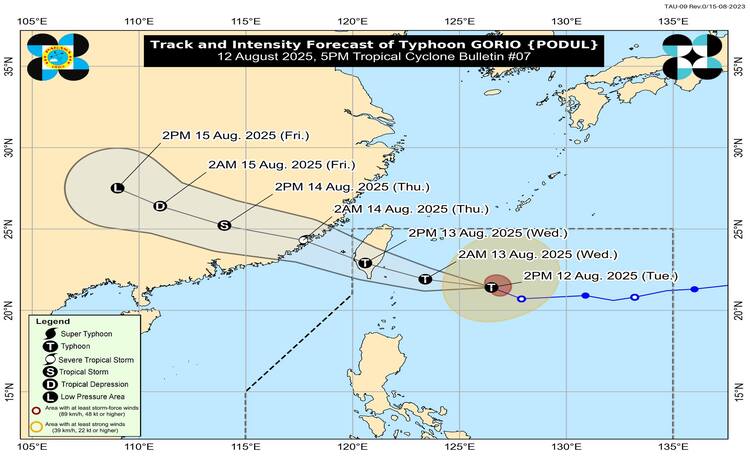
The Philippine Atmospheric, Geophysical and Astronomical Services Administration (PAGASA) reported that Typhoon “Gorio” (international name: Podul) has maintained its strength as it moved west-northwestward over the past six hours.
As of 4:00 PM, the center of Typhoon Gorio was located 440 kilometers east of Itbayat, Batanes (21.5°N, 126.0°E). It carried maximum sustained winds of 120 kilometers per hour near the center, gustiness reaching up to 150 kph, and a central pressure of 975 hPa. The system is moving at 25 kph, with strong to typhoon-force winds extending up to 400 kilometers from its center.
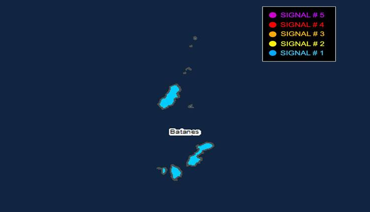
Tropical Cyclone Wind Signals
Tropical Cyclone Wind Signal (TCWS) No. 1 remains in effect over Batanes, indicating strong winds with speeds of 39 to 61 kph possible within 36 hours. PAGASA warns of minimal to minor threats to life and property, with stronger winds possible in coastal and upland areas exposed to the prevailing wind direction.
Based on the current track forecast, the highest possible wind signal for Batanes is TCWS No. 2. A southward shift in the typhoon’s path may lead to expanded areas under wind warnings.
Rainfall, Winds, and Coastal Hazards
Heavy rainfall associated with Gorio is outlined in PAGASA’s 5:00 PM Weather Advisory No. 2. The enhanced Southwest Monsoon will also bring strong to gale-force gusts over:
- August 12: Babuyan Islands, northern mainland Cagayan
- August 13: Babuyan Islands, north mainland Cagayan, eastern Isabela, northern Ilocos Norte
Although no storm surge warning is currently in place, coastal flooding from high waves remains possible, particularly if Gorio’s track shifts southward.
Gale Warning and Sea Conditions
A Gale Warning is raised over the seaboard of Extreme Northern Luzon, with very rough seas reaching up to 9.0 meters around Batanes. Sea travel is considered risky for all vessels in these areas. Rough seas up to 3.5 meters will persist over the northern and eastern seaboards of the Babuyan Islands, while moderate seas are expected in parts of Cagayan, Isabela, and Aurora.
Track and Intensity Outlook
Gorio is forecast to move westward in the next 12 hours before turning west-northwestward. Landfall over southern Taiwan is expected by the morning or afternoon of August 13, with the system likely to exit the Philippine Area of Responsibility by late tomorrow. Intensification is possible before landfall, followed by gradual weakening.
General flood advisories are in effect for Central Luzon, MIMAROPA, Western Visayas, Zamboanga Peninsula, and BARMM.