Issued at 5:00 PM, September 19, 2025
The Philippine Atmospheric, Geophysical and Astronomical Services Administration (PAGASA) reported that Tropical Storm Nando, internationally named Ragasa, has slightly intensified as it continues to track west-northwestward over the Philippine Sea.
As of 4:00 PM, the storm’s center was estimated at 905 kilometers east of Central Luzon, with maximum sustained winds of 85 kilometers per hour (km/h) near the center, gustiness reaching up to 105 km/h, and a central pressure of 996 hPa. It is moving west-northwestward at 10 kilometers per hour. Strong to gale-force winds extend outward up to 400 kilometers from its center.
No Wind Signals Yet, But Alerts Expected
Currently, no Tropical Cyclone Wind Signal (TCWS) is in effect. However, PAGASA said Signal No. 1 may be hoisted over parts of Northern Luzon by tomorrow morning, September 20, as the storm approaches the country’s landmass. Forecasters also warned that Nando could escalate further, with the highest possible alert level reaching Signal No. 5 during its passage.
Heavy Rains and Enhanced Southwest Monsoon
Nando is expected to enhance the Southwest Monsoon (Habagat), bringing heavy rainfall and severe winds to several regions starting Sunday, September 21. The following areas are projected to experience strong to gale-force gusts:
- September 20 (Saturday): Bicol Region, Eastern Visayas, and Caraga
- September 21 (Sunday): CALABARZON, Bicol Region, Visayas, Northern Mindanao, and Caraga
PAGASA cautioned residents in flood- and landslide-prone areas to prepare for possible emergencies, especially in upland and coastal communities exposed to strong winds and rains.
Hazards at Sea and Possible Storm Surge
While Nando is not expected to affect sea conditions within the next 24 hours immediately, rough seas are likely to develop across most of Luzon’s coastal waters beginning Saturday evening. As the storm nears Extreme Northern Luzon, wave heights could increase significantly, with forecasts showing waves reaching up to 14 meters.
A storm surge warning may also be issued tomorrow for coastal waters along Northern Luzon, particularly low-lying and exposed shorelines. Fisherfolk and small sea vessels are strongly advised to remain in port.
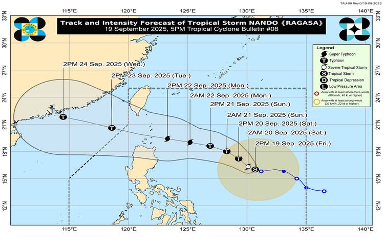
Forecast Track and Strengthening
According to PAGASA’s track forecast, Nando will continue to move northwestward until Saturday before turning slightly west-northwestward towards Extreme Northern Luzon. The storm’s center may pass close to or make landfall over the Babuyan Islands between Monday afternoon (September 22) and early Tuesday morning (September 23). It is expected to exit the Philippine Area of Responsibility (PAR) by Tuesday noon or afternoon.
Nando is projected to intensify while traversing the Philippine Sea, possibly upgrading into a typhoon by Saturday and reaching super typhoon strength by Monday before its close approach to Northern Luzon.
Flood Advisories Issued
As of 6:00 PM today, PAGASA released General Flood Advisories (GFA#1) for Region V (Bicol Region) and Region VIII (Eastern Visayas). These areas are advised to monitor local announcements and prepare for possible flooding from heavy rainfall in the coming days.
PAGASA urged the public to remain vigilant, monitor official updates, and heed the advice of local disaster risk reduction councils as Nando continues to intensify.