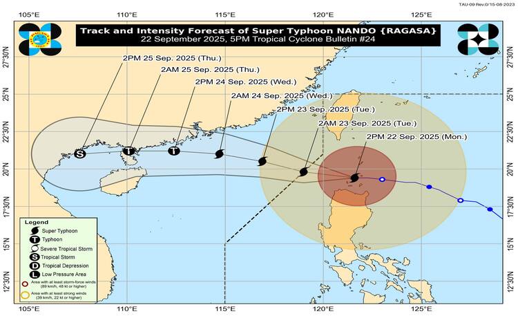
The Philippine Atmospheric, Geophysical and Astronomical Services Administration (PAGASA) released its 5 p.m. bulletin on Monday, September 22, 2025, reporting that Super Typhoon Nando has begun moving away from the Babuyan Islands while maintaining its powerful strength.
As of 4 p.m., the center of Nando’s eye was located west-northwest of the Babuyan group, packing maximum sustained winds of 215 kilometers per hour (kph) and gusts reaching up to 295 kph. The typhoon was moving westward at a speed of 25 kph, bringing widespread heavy rains, violent winds, and coastal threats to Northern Luzon.
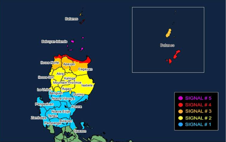
Tropical Cyclone Wind Signals Raised
PAGASA has kept Tropical Cyclone Wind Signals (TCWS) in effect across several provinces:
- Signal No. 5: Babuyan Islands
- Signal No. 4: Southern Batanes, northern mainland Cagayan, and northern Ilocos Norte
- Signal No. 3: Rest of Batanes, central Cagayan, portions of Apayao, and Ilocos Norte
- Signal No. 2: Remaining parts of Cagayan, Isabela, Abra, Kalinga, Mountain Province, Ifugao, northern Benguet, Nueva Vizcaya (Diadi), Ilocos Sur, and northern La Union
- Signal No. 1: Quirino, Nueva Ecija, Bulacan, Tarlac, Pampanga, Zambales, Aurora, Pangasinan, La Union, Quezon (including Polillo Islands), and the remaining areas of Benguet and Nueva Vizcaya
These warnings highlight the danger of destructive winds, storm surges, and life-threatening flash floods in low-lying areas.
Exit Forecast
According to PAGASA’s outlook, Nando is expected to exit the Philippine Area of Responsibility (PAR) by Tuesday morning, September 23. While already at peak intensity, forecasters do not rule out the possibility of the cyclone strengthening slightly before leaving.
Despite moving away, Nando’s expansive circulation will continue to affect large portions of Luzon. The southwest monsoon (habagat), enhanced by the typhoon, will also bring rains and gusty conditions to areas not directly hit by the cyclone.
Impact Beyond Luzon
The weather bureau warned that strong to gale-force winds may still affect Metro Manila, Central Luzon, Calabarzon, and Bicol Region. Similarly, occasional gusts are expected across Mimaropa, the Visayas, Northern Mindanao, Caraga, Zamboanga Peninsula, Bangsamoro, Soccsksargen, and Davao Region.
These conditions could disrupt travel by land, sea, and air, as well as pose risks of landslides and flooding in mountain slopes and river basins.
Authorities strongly advised residents in affected provinces to remain indoors, avoid coastal areas, and heed evacuation advisories. Sea travel remains risky across most seaboards of Luzon and Visayas due to rough to very rough seas.
PAGASA emphasized that while Nando is beginning to move away, its lingering effects from rainbands and the southwest monsoon will continue to impact millions of Filipinos in the coming days.
The next tropical cyclone bulletin is expected later tonight to provide updates on Nando’s movement and any changes in intensity.