The Philippine Atmospheric, Geophysical and Astronomical Services Administration (PAGASA) reported on Wednesday afternoon, September 24, that Tropical Storm “Opong” has intensified into a Severe Tropical Storm while tracking west-northwestward over the Philippine Sea.
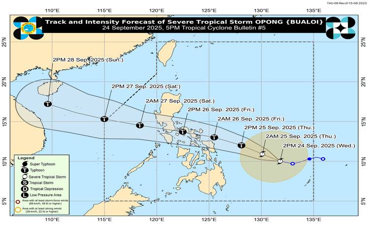
As of 4:00 p.m., the center of Severe Tropical Storm Opong was located 670 kilometers east of Surigao City, Surigao del Norte, carrying maximum sustained winds of 95 kilometers per hour (km/h) near the center and gustiness reaching up to 115 km/h. Its central pressure was measured at 990 hPa, while it continues to move west-northwestward at 20 km/h.
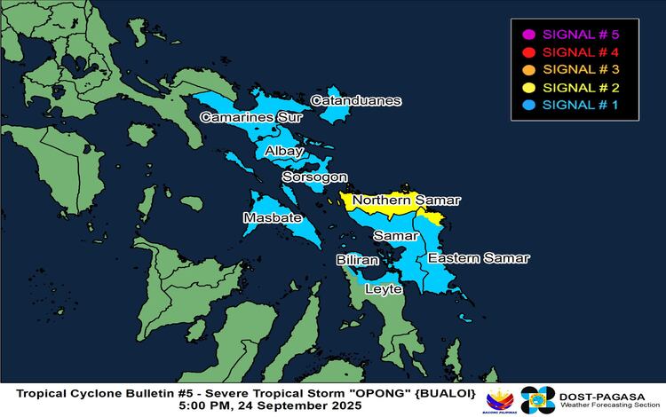
Wind Signals Raised
PAGASA raised Tropical Cyclone Wind Signal (TCWS) No. 2 over Northern Samar and the northern portion of Eastern Samar, which are expected to experience gale-force winds within 24 hours. Winds between 62 to 88 km/h may pose minor to moderate threats to life and property.
Meanwhile, TCWS No. 1 remains in effect over Catanduanes, Camarines Sur, Albay, Sorsogon, Masbate, Samar, the rest of Eastern Samar, Biliran, and parts of Leyte, including Tacloban City. These areas may experience strong winds of 39 to 61 km/h within 36 hours, bringing minimal to minor impacts.
PAGASA warned that higher wind signals, possibly up to Signal No. 4, may still be raised as Opong approaches land.
Rainfall, Winds, and Storm Surge
The state weather bureau cautioned the public against heavy rainfall, severe winds, and storm surges. Coastal areas in Camarines Sur, Catanduanes, Albay, Sorsogon, Masbate, Northern Samar, Eastern Samar, Samar, and Biliran face a moderate to high risk of life-threatening storm surge, with peak heights of 1 to 3 meters possible within 24 hours.
Strong to gale-force winds are also expected, especially in upland and coastal areas exposed to the prevailing wind direction. Enhanced by both Severe Tropical Storm Opong and Super Typhoon Nando, the Southwest Monsoon will bring gusty conditions across Luzon, Visayas, and Mindanao in the coming days.
Sea and Flood Conditions
Moderate to rough seas up to 3 meters are forecast over the eastern seaboards of Northern Samar, Dinagat Islands, and Eastern Samar, with 2.5-meter waves expected in parts of Catanduanes and Davao Oriental. PAGASA advised small vessels and fishermen to avoid venturing out to sea.
General Flood Advisories were also issued for multiple regions, including NCR, CAR, Ilocos, Central Luzon, CALABARZON, MIMAROPA, Bicol, and parts of Visayas.
Forecast Track and Intensity
Opong is expected to continue intensifying while over the Philippine Sea and may reach typhoon category before making landfall over the Bicol Region by Friday, September 26. The storm is forecast to cross Southern Luzon throughout the day and exit into the West Philippine Sea by Saturday, September 27.
Although it will weaken slightly as it traverses the landmass, PAGASA said Opong is likely to remain a typhoon or severe tropical storm during its passage. Re-intensification is highly possible once it re-emerges over the sea.
Authorities are urging residents in affected areas to monitor advisories, prepare for possible evacuations, and heed local government instructions as the storm continues to intensify.