The Philippine Atmospheric, Geophysical and Astronomical Services Administration (PAGASA) released its latest bulletin on Wednesday, October 1, 2025, warning that Tropical Depression Paolo has slightly intensified as it tracks west-northwestward over the Philippine Sea.
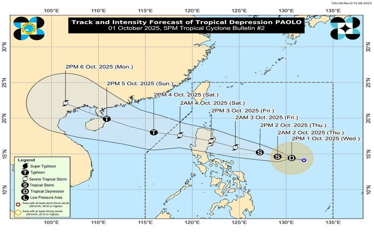
At 4:00 p.m., the center of Paolo was located about 665 kilometers east of Virac, Catanduanes, with maximum sustained winds of 55 kilometers per hour (kph) near the center, gusts of up to 70 kph, and a central pressure of 1002 hPa. The system is currently moving west-northwest at 25 kph. Strong winds extend outward up to 250 kilometers from the center.
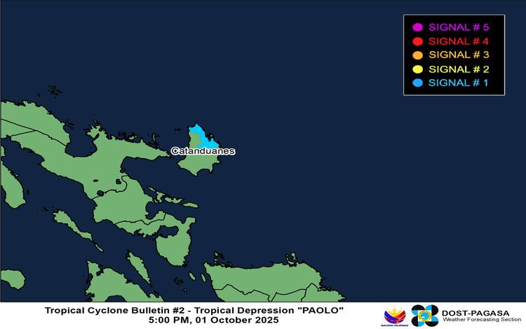
Tropical Cyclone Wind Signals (TCWS)
PAGASA hoisted TCWS No. 1 over the northern portion of Catanduanes, covering the municipalities of Pandan, Bagamanoc, Panganiban, and Viga. Residents in these areas should prepare for strong winds within the next 36 hours, which may bring minimal to minor impacts on life and property. PAGASA added that the highest possible signal to be raised throughout Paolo’s passage could reach Signal No. 3, with a worst-case scenario of Signal No. 4 if the system strengthens into a typhoon before landfall.
Hazards and Rainfall Outlook
While heavy rains are expected, the agency emphasized that severe winds and storm surges remain key threats. A moderate to high risk of life-threatening storm surge, with heights reaching one to two meters, is possible within 48 hours over the low-lying coastal areas of Cagayan, Isabela, and Aurora. PAGASA has already issued Storm Surge Warning No. 1 for these areas.
Rough to very rough sea conditions are also anticipated over the seaboards of Northern and Central Luzon by Thursday, as a gale warning may be raised in preparation for Paolo’s approach. Fisherfolk and small sea vessels are advised against venturing into these waters.
Track and Intensity Forecast
Based on current models, Paolo may make landfall over Isabela or northern Aurora on Friday, October 3, either in the morning or afternoon. While still classified as a tropical depression, PAGASA forecasts that Paolo could intensify into a severe tropical storm by Friday morning and may reach typhoon strength before landfall. Once it crosses mainland Luzon and exits into the West Philippine Sea, re-intensification is considered highly likely.
Flood advisories are in place across multiple regions, including Central Luzon, CALABARZON, Bicol, Visayas, and parts of Mindanao, as authorities warn communities to remain alert for possible flooding and landslides.