November 2, 2025 – Severe Tropical Storm (STS) “TINO” (international name: Kalmaegi) has continued to intensify over the Philippine Sea and is on track for an initial landfall over the Visayas region between late Monday and early Tuesday.
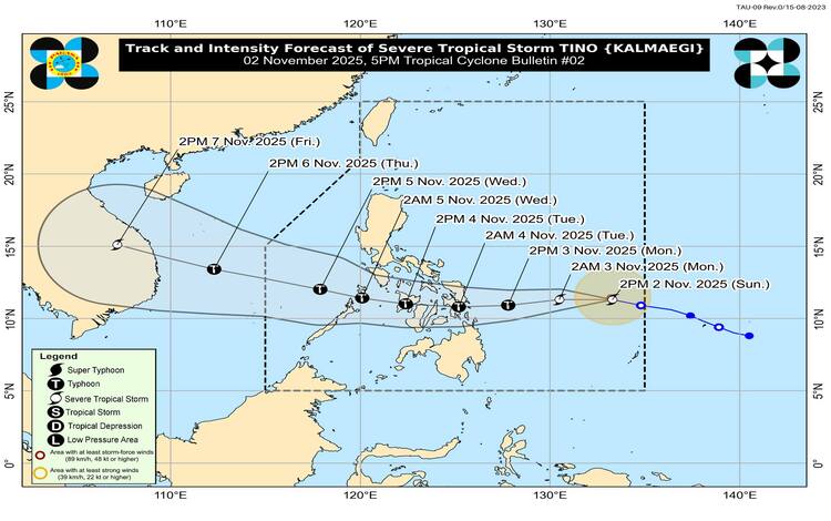
State weather bureau PAGASA has warned that TINO is likely to reach Typhoon category within the next 24 hours, and the possibility of it intensifying into a Super Typhoon before landfall is “not ruled out.”
Latest Track and Intensity (as of 5:00 PM, Sunday, Nov. 2, 2025)
| Detail | Status |
| Current Category | Severe Tropical Storm (STS) |
| Location | 805 km East of Eastern Visayas |
| Maximum Sustained Winds | 95 kilometers per hour (kph) |
| Gustiness | Up to 115 kph |
| Movement | Westward at 30 kph |
| Expected Landfall | Late Monday (Nov. 3) or Early Tuesday (Nov. 4) over Eastern Samar or Dinagat Islands. |
Tropical Cyclone Wind Signals (TCWS) in Effect
Tropical Cyclone Wind Signal (TCWS) No. 1 is currently raised over the following areas, where strong winds (39-61 kph) are expected within the next 36 hours:
| Visayas | Mindanao |
| Eastern Samar | Dinagat Islands |
| Northern Samar | Surigao del Norte (including Siargao and Bucas Grande Islands) |
| Samar | |
| Biliran | |
| Leyte | |
| Southern Leyte | |
| Camotes Islands |
PAGASA has advised that the highest wind warning to be raised during the passage of TINO could reach Signal No. 4, indicating the potential for extreme damage.
Expected Hazards and Impacts
The public is strongly urged to prepare for life-threatening conditions beginning late Monday through Wednesday.
- Torrential Rains: Moderate to heavy (up to torrential) rainfall is expected over Visayas, Caraga, and MIMAROPA during the storm’s passage. Widespread flooding and rain-induced landslides are highly likely.
- Destructive Winds: The storm will bring dangerous winds that can topple power poles, damage structures, and rip roofs, especially in the landfall area.
- High Storm Surge Risk: There is a high risk of life-threatening and damaging storm surges (up to 3 to 7 meters high) within the next 48 hours over the low-lying coastal communities of:
- Sorsogon, Masbate
- Samar Island (Northern, Eastern, and Samar)
- Leyte, Southern Leyte, Biliran
- Cebu, Bohol, Siquijor, Negros Oriental, Negros Occidental
- Capiz, Iloilo, Guimaras
- Dinagat Islands
Click This Link For Live Update: https://www.windy.com/hurricanes?6.839,132.891,3,m:dmOajlA
Suspension of Sea Travel and Classes
- Sea Travel: Sea travel is considered risky for all types of vessels along the eastern seaboard of Eastern Visayas and Caraga, where wave heights could reach up to 7.0 meters. The Philippine Coast Guard has implemented suspensions.
- Classes: Class suspensions are already in effect in multiple Local Government Units (LGUs) across Visayas and Negros Island for November 3 and 4 as a precautionary measure.
ADVICE: Residents in affected areas, especially those in low-lying and coastal communities, are advised to continuously monitor the latest PAGASA weather bulletins, secure their homes, and prepare for evacuation if instructed by local officials. Disaster risk reduction and management offices are on full alert.