The Philippines breathed a collective sigh of relief as Typhoon Uwan continued to weaken over the West Philippine Sea, yet the latest advisory from the Philippine Atmospheric, Geophysical and Astronomical Services Administration (Pagasa) presents a complex forecast: a fleeting exit followed by a possible re-entry.
According to Pagasa Chief Nathaniel Servando, the typhoon is on track to leave the Philippine Area of Responsibility (PAR) either Monday night or early Tuesday morning. However, its journey is not yet over for the region. “It may reenter the Philippine Area of Responsibility (PAR) on Wednesday evening as it makes landfall over the southwestern coast of Taiwan, resulting in further weakening,” Servando explained. He assured that after this brief return, “Uwan will quickly exit PAR for good.”
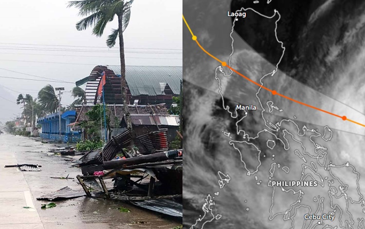
As of 11 a.m. Monday bulletin, Uwan was estimated to be 135 kilometers west-northwest of Bacnotan, La Union. The typhoon was moving west-northwestward at a steady 20 kilometers per hour (kph), carrying maximum sustained winds of 130 kph near the center and gustiness of up to 160 kph.
Despite its distance, the typhoon’s broad circulation means strong winds persist across Luzon. Signal No. 3 remains hoisted over:
- Ilocos Sur
- Northern and central portions of La Union
- Northwestern portion of Pangasinan
This level of warning indicates a serious threat to life and property from strong winds.
Areas under Signal No. 2 include Batanes, Cagayan, Isabela, Quirino, Nueva Vizcaya, Apayao, Abra, Kalinga, Mountain Province, Ifugao, Benguet, Ilocos Norte, and the rest of La Union.
Even distant regions are still affected, with Signal No. 1 in place for Metro Manila, Calabarzon, Oriental Mindoro, Occidental Mindoro, Marinduque, and Romblon. Residents in these areas should still anticipate strong winds and take necessary precautions against possible flooding and minor damage.
The forecast track highlights a typical recurving path for typhoons in the region. After its initial exit, the re-entry on Wednesday is linked to its interaction with the landmass of Taiwan. While this second encounter with land is expected to further degrade the storm’s structure, the brief return to PAR warrants continued vigilance, particularly for maritime activities in the northernmost boundaries.
Authorities strongly urge residents in all areas, especially those under Signal Nos. 2 and 3, to maintain heightened preparedness, heed official warnings, and avoid unnecessary travel until the weather system has definitively moved out of the country.