The Philippine Atmospheric, Geophysical, and Astronomical Services Administration (PAGASA) released its official Weather Forecast for January 13, 2026, warning of continued rains across several regions due to the combined effects of the Shear Line, Northeast Monsoon, and the Intertropical Convergence Zone (ITCZ).
Weather Systems Affecting the Country
The Shear Line continues to influence the eastern section of Northern Luzon, bringing unstable weather conditions. Meanwhile, the Northeast Monsoon (Amihan) is affecting most of Northern Luzon, ushering in cooler temperatures and cloudy skies. In the south, the ITCZ remains active over southern Mindanao, triggering raincloud formation and thunderstorms.
Regional Weather Outlook
Cagayan, Isabela, and Aurora are expected to experience cloudy skies with scattered rains and isolated thunderstorms due to the Shear Line. PAGASA warns of possible flash floods and landslides, especially in mountainous and low-lying areas, as rainfall may become moderate to occasionally heavy.
The Davao Region will also face cloudy skies with scattered rains and thunderstorms brought about by the ITCZ. Similar hazards are expected, with residents advised to remain alert for potential flooding and landslides.
The Cordillera Administrative Region (CAR) and the rest of Cagayan Valley will have cloudy skies with light rains due to the Northeast Monsoon. No significant impacts are anticipated, but travelers should still exercise caution on slippery roads.
Across the Ilocos Region and the rest of Central Luzon, the weather will be partly cloudy to cloudy with isolated light rains, also under the influence of Amihan.
Metro Manila and the rest of the country can expect partly cloudy to cloudy skies with isolated rainshowers or thunderstorms caused by the Easterlies. PAGASA cautions that localized heavy downpours during thunderstorms may trigger flash flooding or landslides.
Wind and Coastal Conditions
Strong winds will affect Northern Luzon, eastern Central Luzon, Southern Luzon, and the Visayas, with moderate to rough coastal waters ranging from 2.1 to 3.5 meters. The eastern section of Mindanao will also experience similar conditions, while the rest of the country will see light to moderate winds and slight to moderate seas.
Small fishing boats and sea travelers are advised to avoid venturing out into open waters under rough sea conditions.
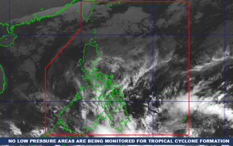
No Tropical Cyclones Monitored
As of 2:00 AM, January 13, 2026, PAGASA confirmed that no Low Pressure Area (LPA) is being monitored for possible tropical cyclone formation.
General Flood Advisories Issued
PAGASA has raised General Flood Advisories for several regions:
- Region II (Cagayan Valley) – GFA #1
- Region III (Central Luzon) – GFA #1
- Region IV-A (CALABARZON) – GFA #2
- Region XI (Davao Region) – GFA #1
- Region XII (SOCCSKSARGEN) – GFA #2