The Philippine Atmospheric, Geophysical and Astronomical Services Administration (PAGASA) released its latest weather bulletin on Tropical Depression Basyang, warning of widespread rains and possible flooding in several parts of the country over the next few days.
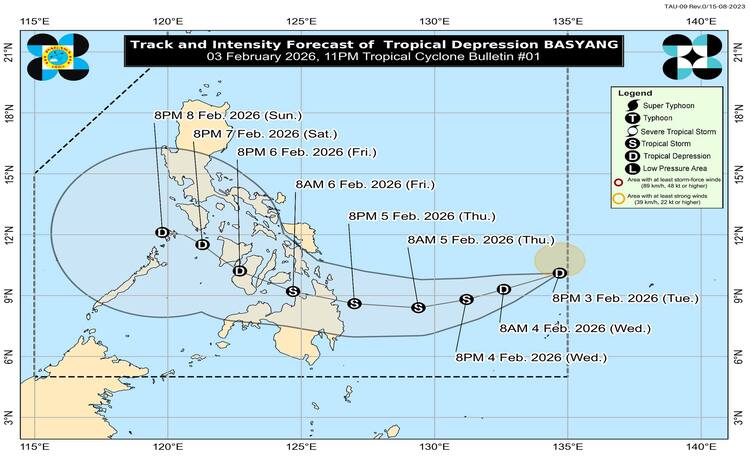
As of 3:00 AM today, the center of Tropical Depression Basyang was located about 895 kilometers east of Northeastern Mindanao, with coordinates at 9.2°N, 133.6°E. The weather disturbance has maximum sustained winds of 55 kilometers per hour near its center and gusts reaching up to 70 kilometers per hour. PAGASA said Basyang is moving west-southwestward at a speed of 20 kilometers per hour. Meanwhile, the Northeast Monsoon continues to affect Luzon, contributing to cloudy skies and occasional rains.
Due to the trough of Tropical Depression Basyang, Eastern Visayas, Central Visayas, Northern Mindanao, Caraga, the Davao Region, North Cotabato, South Cotabato, and Sarangani are expected to experience cloudy skies with scattered rains and thunderstorms. PAGASA warned that moderate to at times heavy rainfall in these areas could trigger flash floods or landslides, especially in low-lying and mountainous locations.
In Cagayan Valley, Apayao, Kalinga, Mountain Province, Ifugao, and Aurora, cloudy skies with rain are forecast as a result of the Northeast Monsoon. Residents in these areas are also advised to remain alert for possible flooding or landslides due to light to moderate, and at times heavy, rainfall. Metro Manila and the rest of Luzon may see partly cloudy to cloudy skies with isolated light rains, with no significant impacts expected. The rest of the country will likely experience isolated rainshowers or thunderstorms caused by localized weather systems, which may still pose risks of flash floods during severe storms.
PAGASA also issued warnings on wind and coastal water conditions. The northern and eastern sections of the country will experience moderate to strong northeast winds, resulting in moderate to rough seas with wave heights ranging from 2.1 to 4.0 meters. The rest of the country will have light to moderate winds, with slight to moderate coastal waters.
Heavy rainfall is expected to intensify in the coming days. Today, rainfall of 50 to 100 millimeters is forecast over Eastern Samar, Southern Leyte, Dinagat Islands, Surigao del Norte, and Surigao del Sur, as well as parts of the Davao Region. Tomorrow, rainfall could reach 100 to 200 millimeters in Dinagat Islands and Surigao provinces. On Friday, February 6, several areas in Eastern Visayas, Caraga, and Northern Mindanao may again experience heavy rainfall of up to 200 millimeters.
PAGASA cautioned that rainfall amounts may be higher in mountainous and elevated areas and that impacts could worsen due to significant antecedent rainfall. Residents are advised to monitor official updates and take necessary precautions.