The Philippine Atmospheric, Geophysical and Astronomical Services Administration (PAGASA) reported early Thursday, February 5, 2026, that Tropical Storm Basyang (international name: Penha) has maintained its strength while moving closer to Eastern Mindanao, prompting wind signals and weather warnings in several parts of the Visayas and Mindanao.
As of 4:00 AM, the center of Basyang was estimated at approximately 440 kilometers east of Hinatuan, Surigao del Sur. The tropical storm is currently packing maximum sustained winds of 65 kilometers per hour near its center, with gusts reaching up to 80 kilometers per hour. PAGASA also recorded the storm’s central pressure at 1000 hPa. The weather disturbance continues to move west-southwestward at 15 kilometers per hour, with strong to gale-force winds extending as far as 300 kilometers from the center.
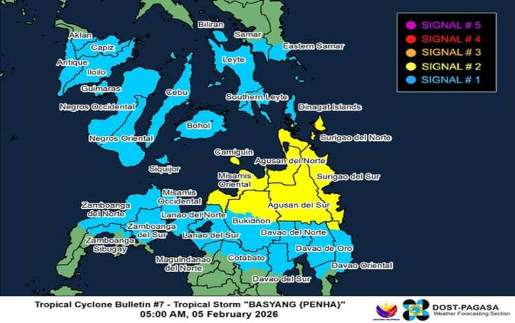
Due to the storm’s strength and expected impact, Tropical Cyclone Wind Signal (TCWS) No. 2 has been raised over several areas in Mindanao. These include Surigao del Norte, including Siargao and Bucas Grande Islands, Surigao del Sur, portions of Davao Oriental, Agusan del Norte, Agusan del Sur, Misamis Oriental, northern Bukidnon, and Camiguin. Under TCWS No. 2, communities may experience gale-force winds ranging from 62 to 88 kilometers per hour, posing minor to moderate threats to life and property.
Meanwhile, TCWS No. 1 has been placed over various provinces in the Visayas and Mindanao. Affected areas include portions of Eastern Samar and Samar, Biliran, Leyte, Southern Leyte, Bohol, Cebu, Siquijor, Negros Oriental, Negros Occidental, Iloilo, Capiz, Guimaras, and parts of Aklan and Antique. Several provinces across Mindanao, including Dinagat Islands, parts of the Davao Region, Lanao provinces, Cotabato, Maguindanao del Norte, and Zamboanga Peninsula, are also under the same wind signal. Residents in these areas may experience strong winds ranging from 39 to 61 kilometers per hour.
Aside from strong winds, Basyang is expected to bring heavy rainfall across affected regions. PAGASA warned that heavy rain may trigger flooding and landslides, especially in low-lying and mountainous areas. Coastal communities in Dinagat Islands, Surigao provinces, Agusan del Norte, Davao Oriental, Misamis Oriental, Camiguin, Leyte, Southern Leyte, Cebu, and Bohol face a minimal to moderate risk of storm surge, with waves possibly reaching up to two meters in height within the next 48 hours.
Sea travel remains extremely dangerous as gale warnings have been issued across the eastern seaboards of the Visayas and Mindanao. Wave heights may reach as high as 5.5 meters in coastal waters of Surigao del Sur, while other nearby seaboards may experience rough to very rough seas. PAGASA strongly advised fishermen and operators of small vessels to remain in port until conditions improve.
Forecast models indicate that Basyang may intensify slightly before making its initial landfall over Surigao del Sur between Thursday night and early Friday morning. The storm is expected to cross Mindanao, emerge over the Bohol Sea, and potentially make another landfall in Negros Oriental. It is projected to move toward the Sulu Sea and northern Palawan by Saturday before weakening into a tropical depression and eventually dissipating into a low-pressure area by February 9.