The Philippine Atmospheric, Geophysical, and Astronomical Services Administration (PAGASA) reported in its latest afternoon update that Tropical Storm Basyang (international name: Penha) has slightly intensified as it continues to move closer to Eastern Mindanao, bringing strong winds, heavy rains, and dangerous sea conditions across several parts of the country.
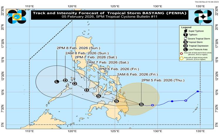
As of 4:00 PM, the center of Tropical Storm Basyang was located approximately 150 kilometers east of Hinatuan, Surigao del Sur. The storm is currently packing maximum sustained winds of 75 kilometers per hour near the center, with gusts reaching up to 90 kilometers per hour. PAGASA also recorded its central pressure at 998 hPa. The storm is moving west-northwestward at a speed of 25 kilometers per hour, carrying strong to gale-force winds that extend up to 380 kilometers from its center.
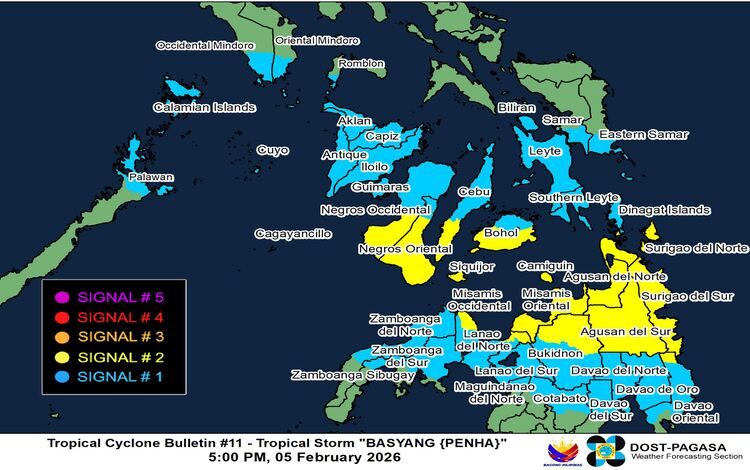
PAGASA has raised Tropical Cyclone Wind Signal (TCWS) No. 2 over several areas in the Visayas and Mindanao, warning residents of possible gale-force winds ranging from 62 to 88 kilometers per hour within 24 hours. Areas under TCWS No. 2 include Siquijor, the southern portions of Negros Oriental and Negros Occidental, southern Cebu, southern Bohol, and several provinces in Northern and Eastern Mindanao, such as Surigao del Norte, Surigao del Sur, Agusan del Norte, Agusan del Sur, Misamis Oriental, Camiguin, and parts of Bukidnon, Lanao del Norte, and Misamis Occidental.
Meanwhile, TCWS No. 1 remains in effect in several parts of Luzon, Visayas, and Mindanao, signaling the possibility of strong winds ranging from 39 to 61 kilometers per hour. These areas include parts of MIMAROPA, Eastern Visayas, Western Visayas, and several provinces in Northern Mindanao and the Zamboanga Peninsula.
Aside from damaging winds, PAGASA warned of heavy rainfall that could trigger flash floods and landslides, particularly in areas vulnerable to saturated soil conditions. Residents are urged to closely monitor official weather advisories and coordinate with local disaster management offices for safety measures.
The surge of the Northeast Monsoon is also expected to enhance strong to gale-force gusts across many parts of the country, including Metro Manila, Central Luzon, Bicol Region, MIMAROPA, Visayas, and large sections of Mindanao. These conditions may persist through the weekend, raising concerns for exposed coastal and mountainous communities.
Coastal areas are also facing potential storm surge risks, with waves reaching up to two meters in low-lying or exposed shorelines, particularly in Occidental and Oriental Mindoro, Palawan, Western Visayas, portions of Central Visayas, and northeastern Mindanao provinces.
Sea travel remains extremely dangerous as PAGASA issued a gale warning across eastern and central Visayas and the northern and eastern seaboards of Mindanao. Wave heights may reach up to 5.5 meters in Surigao del Sur and 5 meters in surrounding coastal waters, making sea travel risky for all types of vessels. Fisherfolk and small boat operators are strongly advised to remain in port until conditions improve.
Forecast models show Basyang may make its initial landfall over Surigao del Sur either tonight or early tomorrow morning. The storm is expected to cross Mindanao and move toward the Bohol Sea, possibly making another landfall near Siquijor or southern Negros Oriental before heading toward Palawan and weakening by the weekend. PAGASA continues to monitor the storm’s movement and intensity as it threatens several regions across the country.