The Philippine Atmospheric, Geophysical and Astronomical Services Administration (PAGASA) reported that Tropical Storm Basyang (international name: Penha) continues to maintain its strength as it moves across Agusan del Norte early Friday morning, February 6, 2026. Authorities continue to warn residents in affected areas to remain alert as the storm brings strong winds, heavy rains, and dangerous sea conditions across several parts of the country.
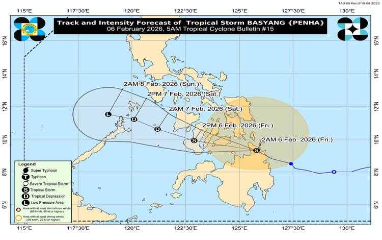
As of 4:00 AM, the center of Tropical Storm Basyang was located in the vicinity of Jabonga, Agusan del Norte, with maximum sustained winds of 65 kilometers per hour and gusts reaching up to 90 kilometers per hour. The storm is currently moving west-northwestward at 25 kilometers per hour. Strong to gale-force winds extend up to 330 kilometers outward from the center, affecting large portions of Mindanao, Visayas, and parts of Luzon.
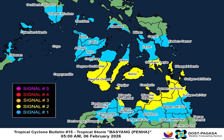
Tropical Cyclone Wind Signal (TCWS) No. 2 remains in effect over several areas, indicating gale-force winds ranging from 62 to 88 kilometers per hour, which pose minor to moderate threats to life and property. In the Visayas, affected areas include Southern Leyte, Bohol, Siquijor, Negros Oriental, and portions of Cebu, Leyte, and Negros Occidental. Meanwhile, in Mindanao, TCWS No. 2 covers Dinagat Islands, Surigao del Norte, parts of Surigao del Sur, Agusan del Norte, portions of Agusan del Sur, Camiguin, Misamis Oriental, northern Bukidnon, and eastern Misamis Occidental.
TCWS No. 1 is also raised in additional areas across Luzon, Visayas, and Mindanao, where residents may experience strong winds ranging from 39 to 61 kilometers per hour. Although impacts are expected to be minimal to minor, PAGASA advises the public to take necessary precautions, especially in areas prone to falling debris, flooding, and landslides.
Aside from strong winds, Basyang is expected to bring heavy rainfall over various regions. PAGASA urges residents to closely monitor official rainfall advisories, as heavy rains may trigger flash floods and landslides, particularly in mountainous and low-lying communities. The Northeast Monsoon is also expected to enhance wind conditions across northern Luzon, Metro Manila, CALABARZON, Bicol Region, and other parts of the country in the coming days.
Coastal communities are likewise warned of possible storm surge risks, with wave heights reaching up to 2 meters in vulnerable coastal areas, including parts of Mindoro, Palawan, Visayas provinces, and several coastal provinces in Mindanao. Authorities are urging residents in low-lying coastal areas to stay alert and follow evacuation orders if necessary.
Sea travel remains highly dangerous due to very rough to rough sea conditions. PAGASA strongly advises all mariners, especially those operating small vessels and motorbancas, to remain in port or seek safe harbor until weather conditions improve.
Forecast models show that Basyang will continue moving west-northwest and is expected to emerge over the Bohol Sea before possibly making another landfall over Bohol and nearby provinces. The storm may gradually weaken into a tropical depression by Saturday and could dissipate into a low-pressure area by Sunday morning.
Residents in affected regions are encouraged to stay updated through official PAGASA bulletins and follow guidance from local disaster management authorities to ensure safety.