The Philippine Atmospheric, Geophysical, and Astronomical Services Administration (PAGASA) has released its weather forecast for February 10, 2026, highlighting the continued effects of the shear line and the Northeast Monsoon, locally known as Amihan, across several parts of the country. Residents, particularly in the Visayas and parts of Luzon and Mindanao, are advised to stay alert for possible weather-related hazards.
According to PAGASA, the shear line is currently affecting the Visayas, Albay, Sorsogon, Masbate, and Dinagat Islands. These areas are expected to experience cloudy skies with scattered rains and isolated thunderstorms throughout the day. The interaction of warm and cold air masses along the shear line may produce moderate to heavy rainfall, which could trigger flash floods and landslides, especially in low-lying and mountainous communities. Authorities are urging residents in vulnerable areas to remain cautious and prepared for sudden changes in weather conditions.
Meanwhile, the Northeast Monsoon continues to influence much of Luzon, including Cagayan Valley, the Cordillera Administrative Region, Central Luzon, the rest of the Bicol Region, and Quezon Province. These areas are forecast to experience cloudy skies with light rain, but no significant weather impacts are expected. Metro Manila and the remaining parts of Luzon will have partly cloudy to cloudy skies with isolated light rains, also with minimal anticipated impact.
In Mindanao, localized thunderstorms are expected to bring partly cloudy to cloudy skies with isolated rain showers and thunderstorms. Although these weather disturbances may be brief, severe thunderstorms could still result in flash floods or landslides in susceptible areas, particularly in elevated or flood-prone locations.
Strong to gale-force winds are expected over the eastern sections of Central and Southern Luzon, as well as the Visayas. Winds will blow from the northeast, producing rough to very rough coastal waters with wave heights ranging from 2.8 to 4.5 meters. Sea travel remains risky in these areas, and small fishing vessels and light watercraft are strongly advised to avoid venturing into open waters. The rest of Luzon and the eastern section of Mindanao will experience moderate to strong winds with moderate to rough seas, while the rest of the country will have light to moderate winds and slight to moderate coastal water conditions.
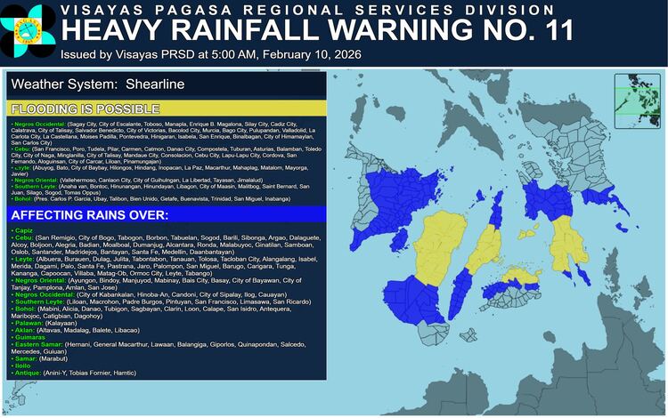
PAGASA also issued a heavy rainfall outlook due to the shear line. For today, rainfall amounts between 50 and 100 millimeters are expected in Negros Occidental, Eastern Samar, Northern Samar, Samar, Leyte, Biliran, Cebu, and Sorsogon. Tomorrow, Albay and Sorsogon are forecast to receive similar rainfall amounts. Higher rainfall accumulation is possible in mountainous areas, and the risk of flooding and landslides may be intensified by previous rainfall in affected regions.
A Yellow Rainfall Warning has been raised in several localities in Negros Occidental, Cebu, Leyte, Negros Oriental, Southern Leyte, and Bohol. Flooding in low-lying areas and landslides in mountainous areas remain possible. Light to moderate rains with occasional heavy rainfall are also being reported in nearby provinces and may persist for the next two to three hours, potentially affecting surrounding communities.
PAGASA has also issued General Flood Advisories for Regions IV-B (MIMAROPA), V (Bicol Region), VI (Western Visayas), VII (Central Visayas), and VIII (Eastern Visayas). Local disaster risk reduction and management offices are encouraged to take precautionary measures to ensure public safety and protect property.