The Philippine Atmospheric, Geophysical and Astronomical Services Administration (PAGASA) reported that the Northeast Monsoon (Amihan) continues to influence large portions of Luzon and the Visayas on March 11, 2026, while a trough from Tropical Storm Nuri is affecting parts of eastern Mindanao. Although the tropical storm remains outside the Philippine Area of Responsibility (PAR), it is being closely monitored for possible weather impacts.
Tropical Storm Nuri Outside PAR
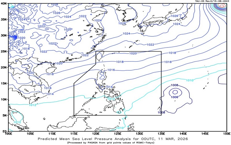
As of 3:00 AM, Tropical Storm “Nuri” (2603) was located approximately 1,290 kilometers east of Eastern Visayas at coordinates 12.0°N, 137.3°E. The storm currently has maximum sustained winds of 65 km/h and gustiness reaching up to 80 km/h. It is moving slowly southwestward over the Philippine Sea.
While the storm is still far from the country, its trough or extension is already bringing increased cloudiness and rainfall to several areas in Mindanao.
Weather Conditions Across the Philippines
Several provinces in eastern Mindanao—including Dinagat Islands, Surigao del Norte, Surigao del Sur, and Davao Oriental—will experience cloudy skies with scattered rains and thunderstorms due to the trough of Tropical Storm Nuri. Residents in these areas are advised to stay alert for possible flash floods or landslides, especially in locations prone to flooding or landslides during periods of moderate to heavy rain.
Meanwhile, the Northeast Monsoon is bringing cloudy skies with light rains over Batanes, Cagayan, Isabela, and Aurora. Despite the cloud cover, no major weather disruptions are expected in these northern provinces.
In Metro Manila, the rest of Luzon, and most of the Visayas, weather conditions will be partly cloudy to cloudy with isolated light rains, also caused by the Northeast Monsoon. These conditions are not expected to cause significant impacts, though occasional showers may occur.
For the remaining areas of Mindanao, localized thunderstorms may bring isolated rain showers, particularly during the afternoon or evening. Severe thunderstorms may still trigger localized flooding or landslides.
Wind and Coastal Water Conditions
Strong winds and rough seas are expected along the eastern sections of Visayas and Mindanao, where northeast to north winds may reach moderate to strong speeds, producing moderate to rough coastal waters ranging from 2.5 to 3.4 meters.
In Luzon, similar moderate to strong northeast winds may generate coastal waves between 1.2 and 3.1 meters. The rest of the country will experience lighter winds with slight to moderate seas ranging from 0.6 to 2.1 meters.
Temperature and Humidity
Over the past 24 hours, temperatures ranged from a minimum of 21.6°C recorded at 5:00 AM to a maximum of 31.3°C recorded at 2:00 PM. Relative humidity varied from 40% in the afternoon to 85% early in the morning, reflecting typical tropical conditions.
Flood Advisories
PAGASA has also issued General Flood Advisories for several regions, including Eastern Visayas, Zamboanga Peninsula, Northern Mindanao, Davao Region, CARAGA, and BARMM. Residents in these areas are advised to monitor official updates and take precautions in case of rising water levels.
Authorities continue to encourage the public to stay informed through official PAGASA bulletins as weather conditions evolve throughout the day.