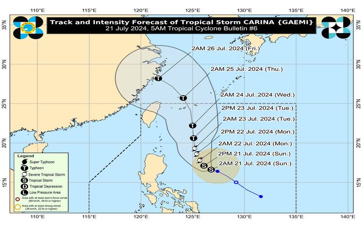
As of 4:00 AM today, the center of Tropical Storm “Carina” was located approximately 490 km east of Casiguran, Aurora, at coordinates 16.7°N, 126.7°E. Carina is currently exhibiting maximum sustained winds of 75 km/h near its center, with gusts reaching up to 90 km/h, and a central pressure of 998 hPa. The storm is moving west-northwestward at a speed of 10 km/h, and its strong to gale-force winds extend up to 320 km from the center.
Tropical Cyclone Wind Signals (TCWS)
At present, no wind signals have been hoisted. However, PAGASA warns that the possibility of hoisting Wind Signal No. 1 over Extreme Northern Luzon and the northeastern portion of mainland Cagayan remains, potentially as early as tonight or tomorrow.
Heavy Rainfall Outlook
PAGASA has issued a heavy rainfall outlook for the next few days:
- Tomorrow (22 July): Expect 50-100 mm of rain in the northeastern portion of mainland Cagayan and the eastern portion of Babuyan Islands.
- Tuesday (23 July): Batanes is forecasted to receive 100-200 mm of rainfall, while Babuyan Islands may see 50-100 mm.
Rainfall amounts are generally higher in elevated or mountainous areas, increasing the risk of flooding and rain-induced landslides, especially in regions highly susceptible to these hazards. Additionally, the enhanced Southwest Monsoon is expected to bring moderate to intense rainfall across various localities in the western portion of Luzon from tomorrow through Tuesday.
Severe Winds
While no wind signals are in effect currently, strong winds associated with Carina may necessitate the hoisting of Wind Signal No. 1. The enhanced Southwest Monsoon, in conjunction with Tropical Depression (formerly Butchoy), is expected to bring strong to gale-force gusts to several areas:
- Today (21 July): Kalayaan Islands
- Tomorrow (22 July): Zambales, Bataan, Metro Manila, CALABARZON, MIMAROPA, Bicol Region, Western Visayas
- Tuesday (23 July): Ilocos Region, Zambales, Bataan, Aurora, Metro Manila, CALABARZON, MIMAROPA, Bicol Region, Western Visayas
Coastal Waters
Moderate seas are expected over the next 24 hours due to Carina and the enhanced Southwest Monsoon. This will affect the coastal waters along the northern seaboard of Northern Luzon, the western seaboards of Central and Southern Luzon, and the eastern seaboard of the country, with wave heights ranging from 1.0 to 2.5 meters. Mariners, especially those on small vessels, are advised to take precautionary measures and avoid navigating under these conditions if possible.
Track and Intensity Outlook
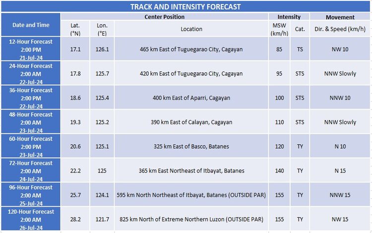
Carina is expected to continue its northwestward movement over the Philippine Sea today and tomorrow, before shifting northward on Tuesday. It is forecasted to remain far from the Philippine landmass and is anticipated to exit the Philippine Area of Responsibility (PAR) by Wednesday while moving near the Ryukyu archipelago. Carina is likely to intensify steadily, potentially reaching severe tropical storm status by tomorrow and typhoon category by Tuesday.
Given these developments, the public and relevant disaster risk reduction and management offices are urged to take necessary precautions to safeguard life and property. Residents in areas highly susceptible to hazards are advised to follow evacuation and other instructions from local officials.