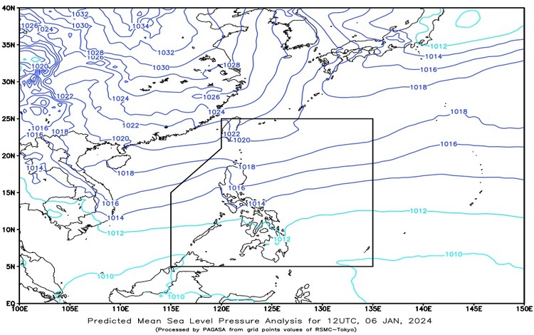
Currently, a Shear Line is affecting the eastern parts of Southern Luzon and Visayas, while the Northeast Monsoon brings cool winds to various parts of Luzon. This is the main aspect of the weather assessment released by the Philippine Atmospheric, Geophysical and Astronomical Services Administration (PAGASA) on January 6, 2024.
The Bicol Region, Caraga, Davao Region, Quezon, Laguna, and Northern Samar are expected to experience cloudy skies with scattered rain showers and thunderstorms due to the influence of the Shear Line and Easterlies. Consequently, there may be potential flash floods or landslides caused by moderate to heavy rainfall.
On the other hand, Cagayan Valley, Apayao, Kalinga, Mountain Province, Ifugao, and Aurora will have overcast skies with light rains brought about by the Northeast Monsoon. No significant impact from the weather is anticipated in these areas.
Meanwhile, in Metro Manila and other parts of Luzon, the weather will be partly cloudy to cloudy with isolated light rains, attributed to the influence of the Northeast Monsoon. However, no significant impact is expected in these areas.
In other parts of the country, particularly in Visayas and Mindanao, partly cloudy to cloudy skies with isolated rain showers or thunderstorms are expected due to Easterlies and localized thunderstorms. This may lead to potential flash floods or landslides, especially in areas affected by intense rainfall.
Regarding wind and sea conditions, moderate to strong winds from the northeast are expected in Luzon, with coastal waters ranging from moderate to rough (1.2 to 2.8 meters). In Visayas and Mindanao, light to moderate winds from the northeast are anticipated, with coastal waters ranging from slight to moderate (0.6 to 2.5 meters).