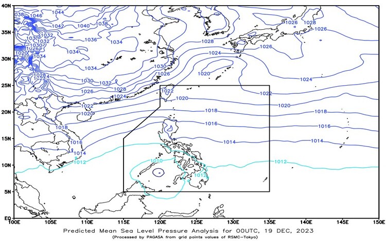
As of 3:00 AM this morning, a Low-Pressure Area (LPA) was identified at a distance of 290 kilometers West-Southwest of Zamboanga City, Zamboanga del Sur (6.0°N, 119.6°E) based on all available data. The Northeast Monsoon is affecting Northern and Central Luzon, while a Shear Line is causing rainfall in the eastern part of Southern Luzon.
Weather Condition Forecast
For areas covering Visayas, Mindanao, MIMAROPA, Bicol Region, Quezon, and Aurora: Expect cloudy skies with scattered rain showers and thunderstorms. Caused By: LPA / Shear Line Impacts: Possible flash floods or landslides due to moderate to heavy rains at times.
For Cagayan Valley and Cordillera Administrative Region: Cloudy skies with rains are anticipated. Caused By: Northeast Monsoon Impacts: Possible flash floods or landslides due to moderate to heavy rains at times.
For Metro Manila and other parts of Luzon: Partly cloudy to cloudy skies with isolated light rains are expected. Caused By: Northeast Monsoon Impacts: No significant impact.
Wind and Coastal Water Condition Forecast
For Extreme Northern Luzon: Wind Speed: Strong Wind Direction: Northeast Coastal Waters: Rough / (2.8 to 4.5 meters)
For the Visayas, the rest of Luzon, and the eastern section of Mindanao: Wind Speed: Moderate to Strong Wind Direction: East to Northeast Coastal Waters: Moderate to Rough / (1.2 to 4.5 meters)
For the rest of Mindanao: Wind Speed: Light to Moderate Wind Direction: East Coastal Waters: Slight to Moderate / (0.6 to 2.5 meters)
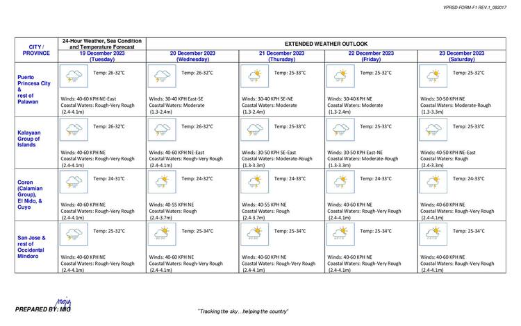
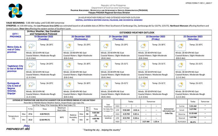
Cloudy skies with scattered rain showers and thunderstorms are expected over the entire Visayas, Palawan including the Kalayaan Islands, and Occidental Mindoro due to the LPA / Shear Line. Moderate to strong winds from the East to Northeast will prevail over Visayas, Palawan including the Kalayaan Islands and Occidental Mindoro with moderate to rough seas.