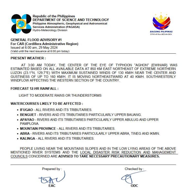
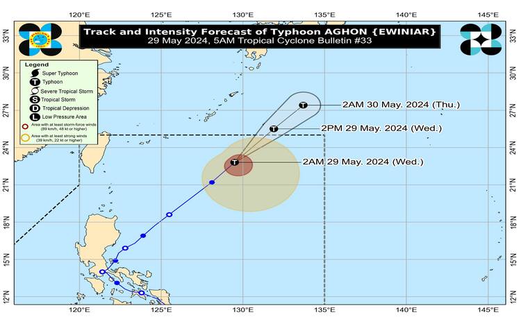
The Philippine Atmospheric, Geophysical and Astronomical Services Administration (PAGASA) has released its latest update on Typhoon “Aghon,” which has maintained its strength while accelerating northeastward. As of 4:00 AM today, the center of Typhoon Aghon was located approximately 870 km east-northeast of Extreme Northern Luzon, at coordinates 23.3°N, 129.8°E.
Intensity and Movement
Typhoon Aghon currently has maximum sustained winds of 130 km/h near its center, with gustiness reaching up to 160 km/h, and a central pressure of 970 hPa. It is moving northeastward at a speed of 40 km/h. The typhoon-force winds extend outward up to 480 km from the center, indicating a broad area of influence.
Tropical Cyclone Wind Signals
Currently, no Tropical Cyclone Wind Signals (TCWS) have been hoisted. However, the typhoon’s effects, particularly through the southwesterly wind flow it influences, are significant.
Heavy Rainfall Outlook
Although Typhoon Aghon is not expected to bring significant rainfall directly within the next three days, the southwesterly wind flow influenced by the typhoon will result in moderate to heavy rains over parts of Northern Luzon, Central Luzon, and MIMAROPA until tomorrow. Residents and local authorities should refer to Weather Advisory No. 5, issued at 11:00 PM yesterday, for detailed information.
Severe Winds
The southwesterly wind flow will also bring occasional gusty conditions over several areas in the coming days:
- Today: Batanes, Ilocos Region, Zambales, Bataan, northern Aurora, southern mainland Quezon, Polillo Islands, Palawan, Lubang Islands, Romblon, Marinduque, and Camarines Norte.
- Tomorrow: Batanes, Ilocos Region, Zambales, Bataan, Lubang Islands, and Kalayaan Islands.
- Friday: Batanes and Ilocos Region.
Residents in these areas should be prepared for these gusty conditions, particularly in coastal and mountainous regions.
Coastal Waters Hazards
The southwesterly wind flow and the associated frontal system will bring moderate to rough seas, with waves reaching 1.0 to 3.0 meters, particularly around Batanes. Mariners operating smaller vessels are advised to take precautionary measures and avoid navigating these waters if inexperienced or operating ill-equipped vessels.
Track and Intensity Outlook
Typhoon Aghon is expected to continue moving northeastward over the Philippine Sea and exit the Philippine Area of Responsibility (PAR) either this morning or afternoon. The typhoon is forecasted to weaken starting tomorrow as it interacts with the mid-latitude environment and begins its transition into a post-tropical state.
Given these developments, the public and relevant disaster risk reduction and management offices are urged to take necessary precautions to protect life and property. Those in areas susceptible to the typhoon’s hazards should heed evacuation and safety instructions from local officials. For further updates on heavy rainfall, thunderstorms, and other severe weather conditions, monitor PAGASA Regional Services Division advisories.
General Flood Advisories
The Philippine Atmospheric, Geophysical, and Astronomical Services Administration (PAGASA) has issued general flood advisories for several regions due to expected heavy rainfall and associated flooding risks. The advisories are as follows:
- Cordillera Administrative Region (CAR): GFA #1Region 1 (Ilocos Region): GFA #1Region 3 (Central Luzon): GFA #1Region 4B (MIMAROPA): GFA #9Region 10 (Northern Mindanao): GFA #2 (Final)