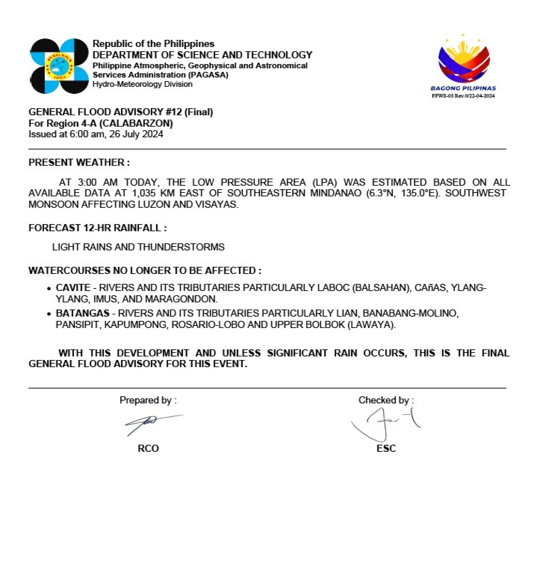
The Low-Pressure Area (LPA) was estimated at 1,035 km East of Southeastern Mindanao (6.3°N, 135.0°E). The Southwest Monsoon is currently affecting the regions of Luzon and Visayas.
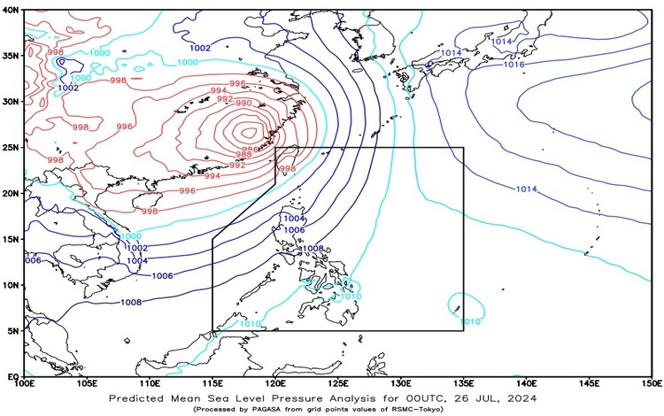
An active tropical cyclone outside the Philippine Area of Responsibility (PAR) has been observed. Severe Tropical Storm Gaemi, formerly known as “Carina,” is located 615 km North Northwest of Itbayat, Batanes (25.5°N, 118.7°E), with maximum sustained winds of 95 km/h and gustiness up to 160 km/h. Gaemi is moving westward at a speed of 15 km/h.
Forecast Weather Conditions
Ilocos Region, Batanes, and Babuyan Islands:
- Weather Condition: Monsoon Rains
- Caused By: Southwest Monsoon
- Impacts: Possible flooding or landslides due to heavy to intense rains with at times torrential rains
Bataan, Zambales, Pampanga, and Benguet:
- Weather Condition: Occasional Rains
- Caused By: Southwest Monsoon
- Impacts: Possible flash floods or landslides due to moderate to heavy rains with at times intense rains
Metro Manila and the rest of Luzon:
- Weather Condition: Cloudy skies with scattered rains and thunderstorms
- Caused By: Southwest Monsoon
- Impacts: Possible flash floods or landslides due to moderate to at times heavy rains
Visayas:
- Weather Condition: Partly cloudy to cloudy skies with isolated rain showers or thunderstorms
- Caused By: Southwest Monsoon
- Impacts: Possible flash floods or landslides during severe thunderstorms
Mindanao:
- Weather Condition: Partly cloudy to cloudy skies with isolated rain showers or thunderstorms
- Caused By: Localized Thunderstorm
- Impacts: Possible flash floods or landslides during severe thunderstorms
Forecast Wind and Coastal Water Conditions
Northern and Western Sections of Luzon:
- Wind Speed: Strong
- Wind Direction: Southwest
- Coastal Waters: Moderate to Rough (2.8 to 4.0 meters)
Visayas and the Rest of Luzon:
- Wind Speed: Moderate to Strong
- Wind Direction: Southwest
- Coastal Waters: Moderate to Rough (2.1 to 3.4 meters)
Mindanao:
- Wind Speed: Moderate to Strong
- Wind Direction: South to Southwest
- Coastal Waters: Moderate to Rough (1.2 to 2.8 meters)
Additional Forecasts
Palawan including Kalayaan Islands and Occidental Mindoro:
- Weather: Mostly cloudy to cloudy skies with scattered rains and thunderstorms due to the Southwest Monsoon.
- Winds: Moderate to Strong from the Southwest.
- Seas: Moderate to Rough.
Visayas:
- Weather: Partly cloudy to cloudy skies with isolated rain showers and thunderstorms due to the Southwest Monsoon.
- Winds: Moderate to Strong from the Southwest.
- Seas: Moderate to Rough.
General Flood Advisories
Issued at 6:00 AM on July 26, 2024, the following regions should be on alert for possible flooding:
- CAR (Cordillera Administrative Region)
- Region 1 (Ilocos Region)
- Region 2 (Cagayan Valley)
- Region 3 (Central Luzon)
- Region 4A (CALABARZON)
- Region 4B (MIMAROPA)
Residents in these areas are advised to take necessary precautions and stay updated on weather bulletins from PAGASA. Given the prevailing conditions, it is crucial to stay informed about the weather developments, particularly those who live in flood-prone or landslide-prone areas. The continuous influence of the Southwest Monsoon suggests a heightened risk of heavy rainfall, potentially leading to significant flooding and landslides.