Severe Tropical Storm CARINA, known internationally as GAEMI, has intensified while remaining almost stationary. As of 4:00 AM today, the center of CARINA was located approximately 420 km east of Tuguegarao City, Cagayan, with coordinates at 17.2°N, 125.7°E. The storm boasts maximum sustained winds of 100 km/h near the center, gusts reaching up to 125 km/h, and a central pressure of 990 hPa.
Current Situation and Movement
CARINA is slowly moving north-northwestward. Its strong to storm-force winds extend outwards up to 360 km from the center.
Tropical Cyclone Wind Signals (TCWS) in Effect
TCWS No. 1 is currently in effect for:
- Luzon: The eastern portion of mainland Cagayan (Santa Ana, Gattaran, Baggao, Peñablanca, Lal-Lo, Gonzaga) and the northeastern portion of Isabela (Divilacan, Palanan, Maconacon).
Wind threat: Strong winds
- Warning lead time: 36 hours
- Range of wind speeds: 39 to 61 km/h (Beaufort 6 to 7)
- Potential impacts of winds: Minimal to minor threat to life and property
Other Hazards Affecting Land Areas
Heavy Rainfall Outlook
Forecast accumulated rainfall:
- Today:
- 100-200 mm: Extreme northeastern portion of mainland Cagayan
- 50-100 mm: Babuyan Islands, eastern portions of mainland Cagayan and Isabela
- Tomorrow (23 July):
- 100-200 mm: Batanes
- 50-100 mm: Babuyan Islands, northeastern portion of mainland Cagayan
- Wednesday (24 July):
- 50-100 mm: Batanes and Babuyan Islands
Flooding and rain-induced landslides are possible, especially in elevated or mountainous areas and localities that have already experienced significant rainfall in recent days. The Southwest Monsoon, enhanced by CARINA, will bring moderate to intense rainfall over various parts of western Luzon from tonight through Wednesday. For further details, refer to Weather Advisory No. 24 issued at 11:00 PM yesterday.
Severe Winds
Minimal to minor impacts due to strong winds may be experienced in areas under TCWS No. 1. Enhanced Southwest Monsoon will also bring strong to gale-force gusts over:
- Today: MIMAROPA, Bicol Region, Western Visayas, Northern Samar, and northern Samar.
- Tomorrow: Zambales, Bataan, Aurora, Metro Manila, CALABARZON, MIMAROPA, Bicol Region, and Visayas.
- Wednesday: Ilocos Region, Abra, Benguet, Nueva Vizcaya, Quirino, Central Luzon, Metro Manila, CALABARZON, MIMAROPA, Bicol Region, and Visayas.
Hazards Affecting Coastal Waters
CARINA and the enhanced Southwest Monsoon will bring moderate to rough seas (1.5 to 3.0 meters) over the northern and eastern seaboards of Northern Luzon. Mariners of small seacrafts are advised against venturing out to sea. Moderate seas are also expected over Central and Southern Luzon seaboards and the eastern seaboards of Visayas and Mindanao.
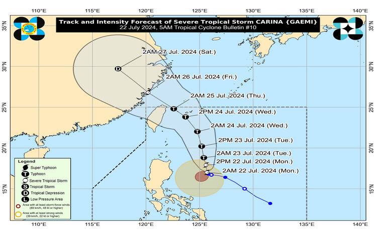
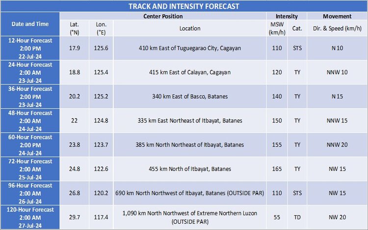
Track and Intensity Outlook
CARINA is forecast to move generally north northwestward to northward until mid-Wednesday while gradually accelerating. It is expected to exit the Philippine Area of Responsibility by Wednesday evening or early Thursday. CARINA will intensify over the next four days, potentially reaching typhoon category within 24 hours and rapidly intensifying further.
The public and disaster risk reduction and management offices are advised to take all necessary measures to protect life and property. Evacuations and other precautions should be followed as instructed by local officials.