As of 4:00 PM today, Super Typhoon Carina, locally named #CarinaPH, was located at 380 km north of Itbayat, Batanes, positioned at 24.2°N, 122.1°E. The super typhoon has intensified significantly, boasting maximum sustained winds of 185 km/h near its center, with gustiness reaching up to 230 km/h. The central pressure of Carina is recorded at 930 hPa. Currently, the typhoon is moving northwestward at a speed of 20 km/h.

The extent of Winds:
Carina’s powerful winds extend up to 700 km from its center, posing a broad threat to surrounding regions.
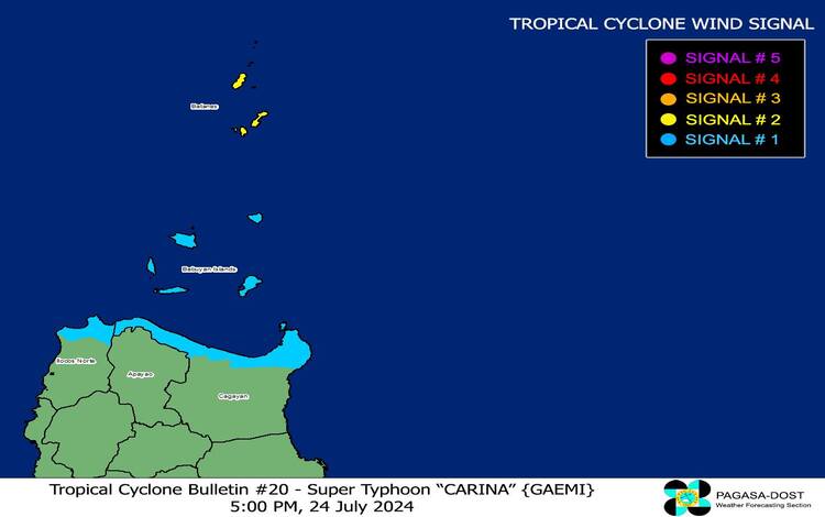
Tropical Cyclone Wind Signals (TCWS)
TCWS No. 2:
- Areas Covered: Batanes
- Wind Threat: Gale-force winds
- Warning Lead Time: 24 hours
- Wind Speeds: 62 to 88 km/h (Beaufort Scale 8 to 9)
- Potential Impacts: Minor to moderate threat to life and property
TCWS No. 1:
- Areas Covered: Babuyan Islands, northern portions of mainland Cagayan (Claveria, Santa Praxedes, Sanchez-Mira, Pamplona, Abulug, Ballesteros, Aparri, Camalaniugan, Buguey, Santa Teresita, Santa Ana, Gonzaga), and northern Ilocos Norte (Burgos, Bangui, Pagudpud, Dumalneg, Adams)
- Wind Threat: Strong winds
- Warning Lead Time: 36 hours
- Wind Speeds: 39 to 61 km/h (Beaufort Scale 6 to 7)
- Potential Impacts: Minimal to minor threat to life and property
Other Hazards Affecting Land Areas
Heavy Rainfall Outlook:
From today to tomorrow afternoon, Batanes and Babuyan Islands can expect accumulated rainfall of 50-100 mm. Rainfall may be higher in elevated or mountainous areas, leading to potential flooding and rain-induced landslides, particularly in regions already susceptible to these hazards or those that have experienced substantial rainfall recently. The Southwest Monsoon, intensified by Carina, is expected to bring moderate to intense rainfall over the western parts of Luzon through Friday.
Severe Winds:
The wind signals indicate potential wind threats across the affected areas, with local winds being stronger in coastal and upland regions exposed to the winds. Minor to moderate impacts from strong winds are anticipated in areas under Wind Signal No. 2, while minimal to minor impacts are expected in areas under Wind Signal No. 1. The enhanced Southwest Monsoon will also bring strong to gale-force gusts over various regions, including:
- Today: Ilocos Region, Cordillera Administrative Region, Nueva Vizcaya, Quirino, eastern Isabela, Central Luzon, Metro Manila, CALABARZON, MIMAROPA, Bicol Region, Visayas, Zamboanga Peninsula, Northern Mindanao, BARMM, and Davao Region.
- Thursday (July 25): Ilocos Region, Cordillera Administrative Region, Nueva Vizcaya, Quirino, eastern Isabela, Central Luzon, Metro Manila, CALABARZON, MIMAROPA, Bicol Region, Western Visayas, Negros Occidental, and Northern Samar.
- Friday (July 26): Ilocos Region, Cordillera Administrative Region, Nueva Vizcaya, Quirino, eastern Isabela, Central Luzon, Metro Manila, CALABARZON, MIMAROPA, Bicol Region, and Western Visayas.
Hazards Affecting Coastal Waters
A Gale Warning is in effect for the coastal waters of Batanes, Babuyan Islands, and the northern portions of Ilocos Norte and Cagayan. Sea travel is highly risky for small seacrafts, including motorbancas. Rough seas (2.5 to 4.0 m) are expected over the seaboards of Northern Luzon outside Gale Warning areas and the western seaboard of Central Luzon. Moderate to rough seas (1.5 to 3.5 m) are also forecasted for the western seaboard of Southern Luzon and the eastern seaboards of Central and Southern Luzon. Mariners are advised against venturing out to sea, especially if inexperienced or operating ill-equipped vessels.
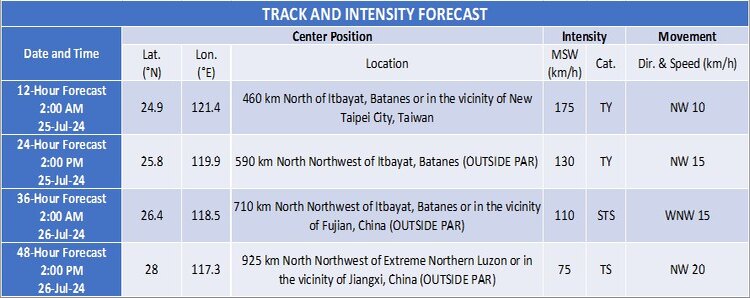
Track and Intensity Outlook
Carina is forecasted to make landfall over northern Taiwan this evening. The super typhoon is expected to traverse Taiwan’s rugged terrain and exit the Philippine Area of Responsibility (PAR) by tomorrow morning (July 25). It will then cross the Taiwan Strait and make its final landfall over southeastern China tomorrow afternoon or evening.
The public and disaster risk reduction offices are urged to take all necessary measures to protect life and property. Residents in high-risk areas should follow evacuation and other instructions from local officials. For detailed rainfall warnings and severe weather information, stay tuned to further advisories.