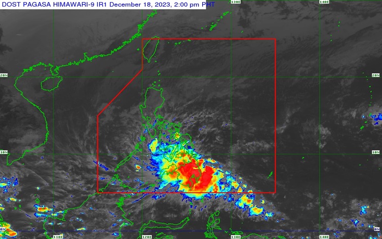
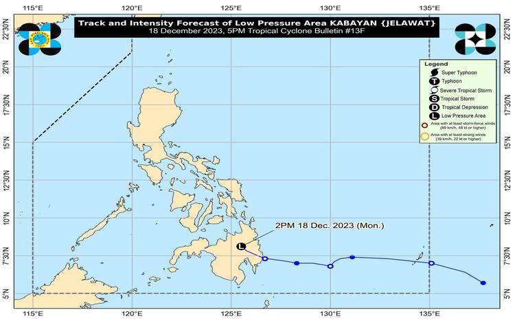
The strength of the Low-Pressure Area, formerly known as “KABAYAN,” has been fluctuating as observed in the central monitoring station located in Impasug-ong, Bukidnon (8.3°N, 125.1°E). Its decreasing pressure is recorded at 1006 hPa, and it is moving northwestward at 25 km/h.
Regarding storm signals, there are currently no Tropical Cyclone Wind Signals (TCWS) in effect. However, there are potential hazards in certain land areas that could have significant impacts on residents.
Heavy rainfall is one of the primary effects of the Low Pressure Area, and the following rainfall forecasts have been issued:
Expected Rainfall From Today Until Tomorrow Afternoon:
- 100-200 mm: Surigao del Sur, Surigao del Norte, Dinagat Islands, Agusan del Sur, Davao del Norte, Davao de Oro, and Davao Oriental.
- 50-100 mm: Central Visayas, Biliran, Leyte, Southern Leyte, Zamboanga del Norte, Northern Mindanao, Davao City, Cotabato, Lanao del Sur, the southern parts of Samar and Eastern Samar, and other areas in Caraga, Davao Oriental, Davao de Oro, and Davao del Norte.
Expected Rainfall From Tomorrow Afternoon Until Wednesday Afternoon:
- 50-100 mm: Mainland Palawan, Cuyo Islands, Cagayancillo Islands, and Kalayaan Islands.
Residents in areas prone to the effects of heavy rainfall, especially in elevated or mountainous regions, are advised to be prepared. Under these conditions, flooding and landslides are likely, particularly in areas highly susceptible to such hazards, as identified in hazard maps and locations that have experienced significant rainfall in recent days.
Furthermore, the Shear Line coinciding with the remnants of KABAYAN may bring heavy rainfall to the eastern portion of Southern Luzon. For additional information, refer to Weather Advisory No. 6 (Intermediate) released at 5:00 PM today, and the 24-Hour Public Weather Forecast and Outlook released at 4:00 PM today.
Various hazards also stem from strong winds due to the Northeast Monsoon. The gusty conditions are expected over the following areas, especially in coastal and upland/mountainous regions:
Expected Hazards from Strong Winds:
- Today and Tomorrow: Most of Luzon and Visayas.
Under the influence of the Northeast Monsoon surge, a Gale Warning is in effect for the coastal waters along the seaboard of Northern Luzon, the eastern and central seaboards of Visayas, and the eastern seaboards of Central Luzon, Southern Luzon, and Mindanao. Sea travel is risky for small seacrafts, and mariners are advised to remain in port or seek safe harbor. For more information, refer to Gale Warning No. 6 issued at 5:00 PM today.
Outside the coastal waters under the Gale Warning, moderate to rough seas are likely over the western seaboards of Central (1.5-3.5 m) and Southern Luzon, the western and northern seaboards of Mindanao, and the remaining seaboard of Visayas (1.25-3.0 m). Mariners of motor bancas and similarly-sized vessels are advised to take precautionary measures while venturing out to sea and, if possible, avoid navigating in these conditions, especially if inexperienced or operating ill-equipped vessels.
In summary, the Low-Pressure Area, formerly known as “KABAYAN,” is expected to continue its northwestward or west-northwestward track, crossing the Philippine archipelago over the next two days while remaining highly disorganized. It will continue to traverse the rugged terrain of Mindanao and emerge over the Sulu Sea from this afternoon until evening. Subsequently, slight environmental improvements may allow the disturbance to reorganize and re-develop into a tropical depression.
Afterward, KABAYAN will move across the Sulu Sea south of the Cagayancillo Islands. It is forecasted to make another crossing over central or southern Palawan by tomorrow morning or afternoon, then emerge over the West Philippine Sea shortly after that. It may pass near or over Kalayaan Islands between tomorrow evening and Wednesday morning