Issued at 5:00 PM, 21 July 2024
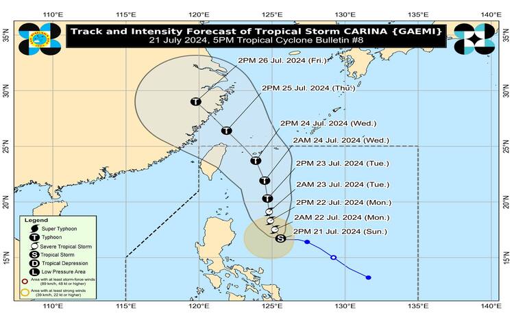
Tropical Storm Carina, locally known as Gaemi, continues to hold its strength as it slows down over the Philippine Sea. At 4:00 PM, Carina was positioned 365 km East Northeast of Casiguran, Aurora (16.9°N, 125.5°E). The storm boasts maximum sustained winds of 85 km/h near its center, gusts reaching up to 115 km/h, and a central pressure of 996 hPa. Currently, Carina is nearly stationary.
Wind Signals and Hazards
No Tropical Cyclone Wind Signals (TCWS) are in effect at this time. However, due to Carina’s potential impact, the hoisting of Wind Signal No. 1 over Extreme Northern Luzon and northeastern mainland Cagayan is possible tonight or tomorrow.
Rainfall Forecast
From today until tomorrow afternoon (22 July), forecasted accumulated rainfall includes:
- 100-200 mm in the eastern portion of Cagayan and Babuyan Islands.
- 50-100 mm in the rest of mainland Cagayan and the northeastern portion of Isabela.
From tomorrow afternoon until Tuesday afternoon (23 July), the expected rainfall is:
- 100-200 mm in Batanes, the eastern portion of Cagayan, and Babuyan Islands.
- 50-100 mm in the rest of mainland Cagayan and the northeastern portion of Isabela.
From Tuesday afternoon (23 July) to Wednesday afternoon (24 July), Batanes could see 100-200 mm of rain, while Babuyan Islands might receive 50-100 mm.
In elevated or mountainous regions, rainfall is generally higher. These conditions could lead to flooding and rain-induced landslides, particularly in highly susceptible areas or regions that have experienced significant rainfall recently.
Enhanced Southwest Monsoon
The Southwest Monsoon, intensified by Carina and Tropical Storm Prapiroon (formerly Butchoy), will bring moderate to intense rainfall over parts of western Luzon from tomorrow through Tuesday. Strong to gale-force gusts are expected over MIMAROPA, Bicol Region, Western Visayas, Northern Samar, and the northern portion of Samar (province) today and tomorrow. From tomorrow afternoon to Tuesday afternoon, Zambales, Bataan, Metro Manila, CALABARZON, MIMAROPA, Bicol Region, and Visayas will experience these conditions. The same areas will continue to be affected from Tuesday afternoon to Wednesday afternoon, with additional impacts on the Ilocos Region and Central Luzon.
Coastal Hazards
In the next 24 hours, moderate to rough seas (1.5-3.5 m) are expected along the northern and eastern seaboard of the country, with the western seaboards of Central and Southern Luzon seeing seas of 1.5-3.0 m. Mariners operating small seacrafts are advised against venturing out, especially if inexperienced or using ill-equipped vessels.
Track and Intensity Outlook
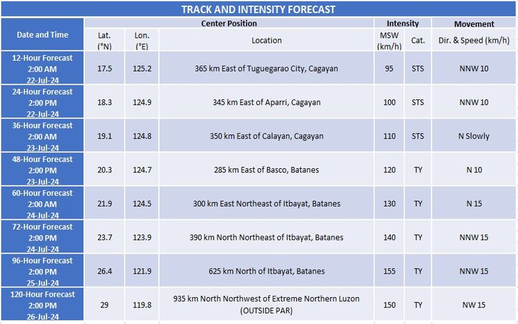
Carina is predicted to move generally north-northwestward to northward until Tuesday (23 July), remaining distant from the Philippine landmass. The storm is expected to exit the Philippine Area of Responsibility by Wednesday night (24 July) or early Thursday (25 July), moving near the Ryukyu Islands. Carina is forecast to intensify, becoming a severe tropical storm by tonight and potentially reaching typhoon status by tomorrow evening. Rapid intensification is possible.
Public Advisory
Residents and disaster management offices are urged to take necessary precautions to protect life and property. Those in high-risk areas should follow local officials’ evacuation and safety instructions. For localized severe weather updates, monitor advisories from PAGASA Regional Services Divisions.