Issued at 11:00 AM, 23 July 2024
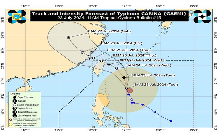
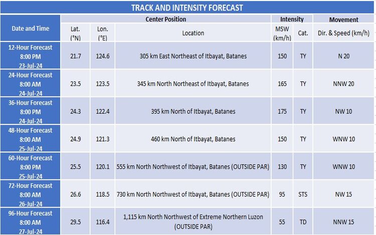
Typhoon Carina, internationally known as Gaemi, has slightly intensified as it continues to move northward over the Philippine Sea. The center of the typhoon was located 320 km east of Basco, Batanes, or 405 km northeast of Aparri, Cagayan, as of 10:00 AM today. It is moving northward at a speed of 15 km/h.
Intensity and Movement
Typhoon Carina now carries maximum sustained winds of 140 km/h near its center, with gusts reaching up to 170 km/h and a central pressure of 965 hPa. The typhoon-force winds extend up to 520 km from the center, indicating a broad area of impact.
Tropical Cyclone Wind Signals (TCWS) in Effect
- TCWS No. 2 has been raised over Batanes (Itbayat, Basco, Mahatao, Uyugan, Ivana), warning of gale-force winds with speeds ranging from 62 to 88 km/h. These winds pose a minor to moderate threat to life and property, with a lead time of 24 hours.
- TCWS No. 1 covers the rest of Batanes (Sabtang), Cagayan including Babuyan Islands, eastern Isabela, northern Apayao, northern Ilocos Norte, northern Aurora, Polillo Islands, Calaguas Islands, and northern Catanduanes. This signal warns of strong winds between 39 to 61 km/h, posing minimal to minor threats, with a lead time of 36 hours.
Rainfall Outlook
Significant rainfall is expected from today through Friday, with the highest accumulations predicted for Batanes and parts of northern Luzon:
- From today to tomorrow noon: 100-200 mm in Batanes, Babuyan Islands, northern and eastern Mainland Cagayan, and Ilocos Sur; 50-100 mm in Ilocos Norte, La Union, Abra, Benguet, Apayao, eastern Isabela, and the rest of Cagayan.
- Tomorrow noon to Thursday noon: 100-200 mm in Batanes; 50-100 mm in Babuyan Islands.
- Thursday noon to Friday noon: 50-100 mm in Batanes.
Flooding and landslides are possible, especially in mountainous areas and those that have experienced recent heavy rains.
Severe Winds
Areas under Wind Signal No. 2 should prepare for minor to moderate impacts from strong winds, while those under Wind Signal No. 1 should expect minimal impacts. Enhanced winds from the Southwest Monsoon will affect various regions across Luzon, Visayas, and Mindanao over the next few days.
Hazards Affecting Coastal Waters
A Gale Warning is in effect for the coastal waters of Batanes and Babuyan Islands. Rough seas are expected, making sea travel risky for small seacrafts. Mariners are advised to avoid sea travel under these conditions.
Track and Intensity Outlook
Carina is expected to move north-northwestward, accelerating before turning northwestward tomorrow. It will remain far from the Philippine landmass but is forecast to make landfall over northern Taiwan by tomorrow evening or Thursday morning, then exit the Philippine Area of Responsibility shortly after. It may intensify further before weakening upon landfall in Taiwan.
The public is urged to stay updated on the latest bulletins and advisories and take necessary precautions to ensure safety.