TYPHOON “CARINA” CONTINUES TO INTENSIFY WHILE HEADING TOWARD TAIWAN
Location of Center (10:00 AM):
The center of the eye of Typhoon CARINA was estimated based on all available data at 345 km North Northeast of Itbayat, Batanes (23.7°N, 123.0°E)
Intensity:
Maximum sustained winds of 165 km/h near the center, gustiness of up to 205 km/h, and central pressure of 940 hPa
Present Movement:
North Northwestward at 15 km/h
Extent of Tropical Cyclone Winds:
Strong to typhoon-force winds extend outwards up to 700 km from the center
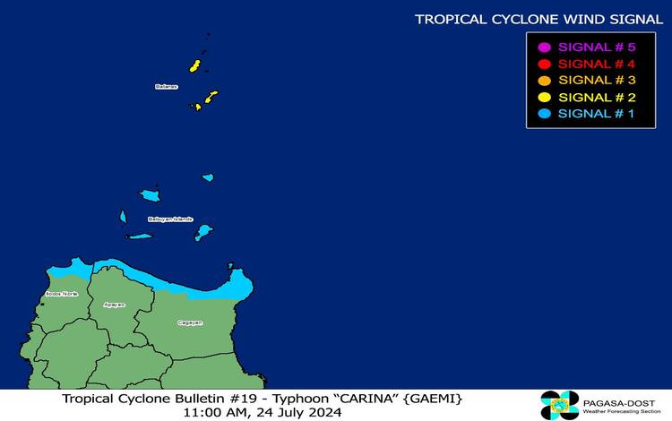
TROPICAL CYCLONE WIND SIGNALS (TCWS) IN EFFECT
TCWS No. 2
Wind threat: Gale-force winds
Warning lead time: 24 hours
Range of wind speeds: 62 to 88 km/h (Beaufort 8 to 9)
Potential impacts of winds: Minor to moderate threat to life and property
LUZON:
Batanes
TCWS No. 1
Wind threat: Strong winds
Warning lead time: 36 hours
Range of wind speeds: 39 to 61 km/h (Beaufort 6 to 7)
Potential impacts of winds: Minimal to minor threat to life and property
LUZON:
Babuyan Islands, the northern portion of mainland Cagayan (Claveria, Santa Praxedes, Sanchez-Mira, Pamplona, Abulug, Ballesteros, Aparri, Camalaniugan, Buguey, Santa Teresita, Santa Ana, Gonzaga), and the northern portion of Ilocos Norte (Burgos, Bangui, Pagudpud, Dumalneg, Adams)
OTHER HAZARDS AFFECTING LAND AREAS
Heavy Rainfall Outlook
Forecast accumulated rainfall: From today to tomorrow noon
50-100 mm: Batanes and Babuyan Islands
Forecast rainfall is generally higher in elevated or mountainous areas. Under these conditions, flooding and rain-induced landslides are possible, especially in areas that are highly or very highly susceptible to these hazards as identified in official hazard maps and in localities that experienced considerable amounts of rainfall for the past several days. Furthermore, the Southwest Monsoon enhanced by CARINA will bring moderate to intense rainfall over various localities in the western portion of Luzon today through Friday. For more information, refer to Weather Advisory No. 29 issued at 11:00 AM yesterday.
Severe Winds
The wind signals warn the public of the general wind threat over an area due to the tropical cyclone. Local winds may be slightly stronger/enhanced in coastal and upland/mountainous areas exposed to winds. Winds are less strong in areas sheltered from the prevailing wind direction.
Minor to moderate impacts from strong winds are possible within any of the localities where Wind Signal No. 2 is hoisted.
Minimal to minor impacts from strong winds are possible within any of the areas under Wind Signal No. 1.
The Southwest Monsoon enhanced by CARINA will also bring strong to gale-force gusts over the following areas (especially in coastal and upland areas exposed to winds):
Today: Ilocos Region, Cordillera Administrative Region, Nueva Vizcaya, Quirino, the eastern portion of Isabela, Central Luzon, Metro Manila, CALABARZON, MIMAROPA, Bicol Region, Visayas, Zamboanga Peninsula, Northern Mindanao, BARMM, and Davao Region
Thursday (25 July): Ilocos Region, Cordillera Administrative Region, Nueva Vizcaya, Quirino, the eastern portion of Isabela, Central Luzon, Metro Manila, CALABARZON, MIMAROPA, Bicol Region, Western Visayas, Negros Occidental, and Northern Samar
Friday (26 July): Ilocos Region, Cordillera Administrative Region, Nueva Vizcaya, Quirino, the eastern portion of Isabela, Central Luzon, Metro Manila, CALABARZON, MIMAROPA, Bicol Region, and Western Visayas.
HAZARDS AFFECTING COASTAL WATERS
Gale Warning is in effect over the coastal waters of Batanes, Babuyan Islands, and the northern portion of Ilocos Norte and Cagayan. Sea travel is risky for small seacrafts, including all types of motorbancas. For more information, refer to Gale Warning No. 4 (Intermediate) issued at 11:00 AM today.
In the next 24 hours, CARINA and the enhanced Southwest Monsoon will bring rough seas over the seaboards of Northern Luzon (2.5 to 4.0 m) outside Gale Warning areas, and the western seaboard of Central Luzon (2.5 to 4.0 m). Moderate to rough seas are also expected over the western seaboard of Southern Luzon (1.5 to 3.5 m) and the eastern seaboards of Central and Southern Luzon (1.5 to 3.0 m) Mariners of small seacrafts, including all types of motorbancas, are advised not to venture out to sea under these conditions, especially if inexperienced or operating ill-equipped vessels.
Moderate seas are also expected over the southern seaboard of Southern Luzon (1.5 to 2.5 m), the western and eastern seaboards of Visayas, and the eastern seaboard of Mindanao (1.5 to 2.0 m). Mariners of motorbancas and similarly-sized vessels are advised to take precautionary measures while venturing out to sea and, if possible, avoid navigation under these conditions.
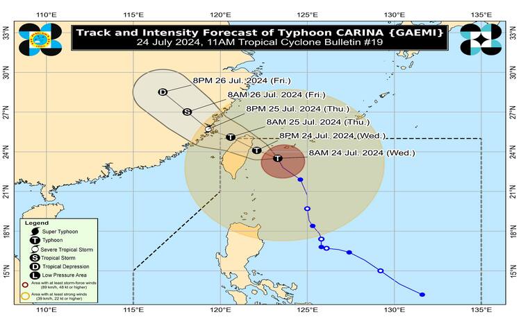
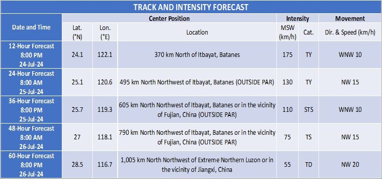
TRACK AND INTENSITY OUTLOOK
CARINA is forecast to make landfall over the northern portion of Taiwan this evening or tomorrow early morning. According to the track forecast, the typhoon will cross the rugged terrain of Taiwan and exit the Philippine Area of Responsibility (PAR) tomorrow (25 July) morning. Outside the PAR Region, CARINA will cross the Taiwan Strait and make its final landfall over southeastern China tomorrow afternoon or evening.
CARINA is forecast to steadily intensify and may reach its peak intensity before its landfall over Taiwan due to the favorable environment. Its landfall over northern Taiwan will trigger a weakening trend for the rest of the forecast period. The possibility of reaching the Super Typhoon category before landfall in Taiwan is not ruled out.
Considering these developments, the public and disaster risk reduction and management offices concerned are advised to take all necessary measures to protect life and property. Persons living in areas identified to be highly or very highly susceptible to these hazards are advised to follow evacuation and other instructions from local officials. For heavy rainfall warnings, thunderstorm/rainfall advisories, and other severe weather information specific to your area, please refer to local Pagasa offices. Keep monitoring for updates on Typhoon Carina as the situation develops.
ADDITIONAL INFORMATION AND GUIDANCE
Emergency Preparedness:
Residents in affected areas should ensure they have emergency kits prepared, including food, water, medications, and essential documents. Those in coastal areas should be prepared for possible storm surges and flooding. It is crucial to stay indoors and avoid unnecessary travel during the height of the typhoon to ensure personal safety.
Evacuation Plans:
Local government units (LGUs) are advised to activate their emergency response teams and coordinate with Pagasa for timely and accurate information. Evacuation centers should be prepared to accommodate displaced residents, ensuring that health protocols are observed to prevent the spread of diseases, especially in crowded conditions.
Communication and Updates:
Keep communication lines open with family members and local authorities. Regularly check for updates from Pagasa and other reliable sources to stay informed about the typhoon’s progress and any changes in its path or intensity.
Support for Vulnerable Groups:
Special attention should be given to vulnerable groups such as the elderly, children, and individuals with disabilities. Ensure they have adequate support and are evacuated to safe locations if necessary.