Issued at 5:00 PM, 22 July 2024 | Valid until 11:00 PM Today
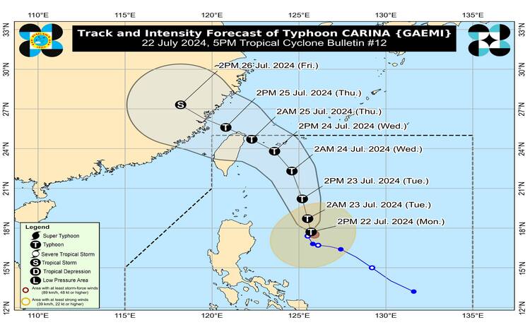
Typhoon CARINA has strengthened as it continues to meander over the Philippine Sea. As of 4:00 PM, the center of the typhoon was located 420 km east of Tuguegarao City, Cagayan, at coordinates 17.9°N, 125.7°E. The typhoon now boasts maximum sustained winds of 120 km/h near the center, with gustiness reaching up to 150 km/h and a central pressure of 980 hPa. CARINA is currently moving north-northeastward slowly, and its strong typhoon-force winds extend up to 300 km from the center.
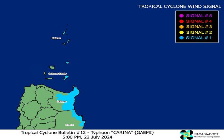
Tropical Cyclone Wind Signals (TCWS) in Effect:
- TCWS No. 1: Wind threat: Strong winds (39 to 61 km/h, Beaufort 6 to 7)
- Warning lead time: 36 hours
- Potential impacts: Minimal to minor threat to life and property
Affected Areas:
- Luzon: Batanes, the eastern portion of mainland Cagayan (including Santa Ana, Gattaran, Baggao, Peñablanca, Lal-Lo, Gonzaga), the eastern portion of Babuyan Islands (Camiguin Is., Babuyan Is.), and the northeastern portion of Isabela (Divilacan, Palanan, Maconacon).
Heavy Rainfall Outlook:
- Today to Tomorrow Noon (23 July):
- 100-200 mm: Extreme northeastern portion of mainland Cagayan
- 50-100 mm: Babuyan Islands and eastern portions of mainland Cagayan and Isabela
- Tomorrow Noon (23 July) to Wednesday Noon (24 July):
- 100-200 mm: Batanes
- 50-100 mm: Babuyan Islands and northeastern portion of mainland Cagayan
- Wednesday Noon (24 July) to Thursday Noon (25 July):
- 50-100 mm: Batanes
Flooding and Rain-Induced Landslides: Flooding and rain-induced landslides are possible, especially in highly susceptible areas and those that have received significant rainfall in recent days. The Southwest Monsoon, enhanced by CARINA, will also bring moderate to intense rainfall over various localities in western Luzon tonight through Wednesday.
Severe Winds: Minimal to minor impacts due to strong winds are expected within the areas under TCWS No. 1. The Southwest Monsoon will also bring strong to gale-force gusts over the following areas:
- Today: Zambales, Bataan, Aurora, Metro Manila, CALABARZON, MIMAROPA, Bicol Region, and Visayas
- Tomorrow: Ilocos Region, Zambales, Bataan, Aurora, Metro Manila, CALABARZON, MIMAROPA, Bicol Region, Visayas, Zamboanga Peninsula, and Davao Region
- Wednesday: Ilocos Region, Abra, Benguet, Apayao, Nueva Vizcaya, Quirino, Isabela, Central Luzon, Metro Manila, CALABARZON, MIMAROPA, Bicol Region, Western Visayas, Northern Samar, and the northern portion of Samar
Hazards Affecting Coastal Waters: Moderate to rough seas are expected over the northern and eastern seaboards of Luzon (2.0 to 4.0 m) and western seaboards of Central and Southern Luzon, and Western Visayas (1.5 to 3.0 m). Mariners, especially those operating small seacrafts, are advised against venturing out to sea.
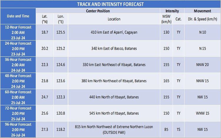
Track and Intensity Outlook: CARINA is expected to move generally north-northwestward, gradually accelerating before turning northwestward. It is forecast to exit the Philippine Area of Responsibility by Wednesday evening or early Thursday morning. CARINA is likely to intensify steadily over the next four days.
The public and disaster risk reduction offices are advised to take necessary precautions. Follow local evacuation instructions and stay informed through updates on heavy rainfall warnings, thunderstorm advisories, and other severe weather information. The typhoon now boasts maximum sustained winds of 120 km/h near the center, with gustiness reaching up to 150 km/h and a central pressure of 980 hPa. CARINA is currently moving north-northeastward slowly, and its strong to typhoon-force winds extend up to 300 km from the center.
Tropical Cyclone Wind Signals (TCWS) in Effect:
- TCWS No. 1: Wind threat: Strong winds (39 to 61 km/h, Beaufort 6 to 7)
- Warning lead time: 36 hours
- Potential impacts: Minimal to minor threat to life and property
Affected Areas:
- Luzon: Batanes, the eastern portion of mainland Cagayan (including Santa Ana, Gattaran, Baggao, Peñablanca, Lal-Lo, Gonzaga), the eastern portion of Babuyan Islands (Camiguin Is., Babuyan Is.), and the northeastern portion of Isabela (Divilacan, Palanan, Maconacon).
Heavy Rainfall Outlook:
- Today to Tomorrow Noon (23 July):
- 100-200 mm: Extreme northeastern portion of mainland Cagayan
- 50-100 mm: Babuyan Islands and eastern portions of mainland Cagayan and Isabela
- Tomorrow Noon (23 July) to Wednesday Noon (24 July):
- 100-200 mm: Batanes
- 50-100 mm: Babuyan Islands and northeastern portion of mainland Cagayan
- Wednesday Noon (24 July) to Thursday Noon (25 July):
- 50-100 mm: Batanes
Flooding and Rain-Induced Landslides: Flooding and rain-induced landslides are possible, especially in highly susceptible areas and those that have received significant rainfall in recent days. The Southwest Monsoon, enhanced by CARINA, will also bring moderate to intense rainfall over various localities in western Luzon tonight through Wednesday.
Severe Winds: Minimal to minor impacts due to strong winds are expected within the areas under TCWS No. 1. The Southwest Monsoon will also bring strong to gale-force gusts over the following areas:
- Today: Zambales, Bataan, Aurora, Metro Manila, CALABARZON, MIMAROPA, Bicol Region, and Visayas
- Tomorrow: Ilocos Region, Zambales, Bataan, Aurora, Metro Manila, CALABARZON, MIMAROPA, Bicol Region, Visayas, Zamboanga Peninsula, and Davao Region
- Wednesday: Ilocos Region, Abra, Benguet, Apayao, Nueva Vizcaya, Quirino, Isabela, Central Luzon, Metro Manila, CALABARZON, MIMAROPA, Bicol Region, Western Visayas, Northern Samar, and the northern portion of Samar
Hazards Affecting Coastal Waters: Moderate to rough seas are expected over the northern and eastern seaboards of Luzon (2.0 to 4.0 m) and western seaboards of Central and Southern Luzon, and Western Visayas (1.5 to 3.0 m). Mariners, especially those operating small seacrafts, are advised against venturing out to sea.
Track and Intensity Outlook: CARINA is expected to move generally north-northwestward, gradually accelerating before turning northwestward. It is forecast to exit the Philippine Area of Responsibility by Wednesday evening or early Thursday morning. CARINA is likely to intensify steadily over the next four days.
The public and disaster risk reduction offices are advised to take necessary precautions. Follow local evacuation instructions and stay informed through updates on heavy rainfall warnings, thunderstorm advisories, and other severe weather information.