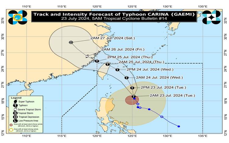
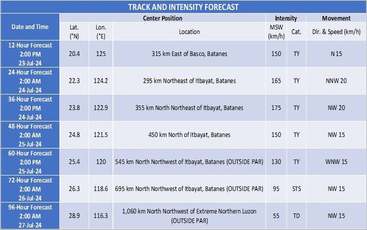
The Philippine Atmospheric, Geophysical, and Astronomical Services Administration (PAGASA) has released the latest update on Typhoon “Carina” (international name: Gaemi). As of 5:00 AM today, the center of Typhoon Carina was located approximately 380 kilometers east of Aparri, Cagayan (18.9°N, 125.2°E).
Intensity and Movement
Carina is currently packing maximum sustained winds of 130 km/h near its center, with gusts reaching up to 160 km/h. The central pressure stands at 975 hPa. The typhoon is moving north-northwestward at a speed of 10 km/h, and its strong typhoon-force winds extend outward up to 560 km from the center.
Tropical Cyclone Wind Signals (TCWS) in Effect
TCWS No. 1
- Wind Threat: Strong winds
- Warning Lead Time: 36 hours
- Range of Wind Speeds: 39 to 61 km/h (Beaufort 6 to 7)
- Potential Impacts: Minimal to minor threat to life and property
Luzon Areas under TCWS No. 1: Batanes, Babuyan Islands, northern and eastern portions of mainland Cagayan, the eastern portion of Isabela, the northern portion of Apayao, the northern portion of Ilocos Norte, the northern portion of Aurora, Polillo Islands, Calaguas Islands, and the northern portion of Catanduanes.
Other Hazards Affecting Land Areas
Heavy Rainfall Outlook
Today (23 July):
- 100-200 mm: Batanes, Babuyan Islands
- 50-100 mm: Ilocos Norte, Ilocos Sur, La Union, Abra, Benguet, Apayao, and Cagayan
Tomorrow (24 July):
- 100-200 mm: Batanes
- 50-100 mm: Babuyan Islands
Thursday (25 July):
- 50-100 mm: Batanes
Rainfall will be generally higher in elevated or mountainous areas, posing risks of flooding and rain-induced landslides, especially in susceptible areas as identified in official hazard maps and those that have experienced significant rainfall in the past days. The Southwest Monsoon enhanced by Carina is expected to bring moderate to intense rainfall across various parts of western Luzon from today through Thursday.
Severe Winds
Strong winds will have minimal to minor impacts in areas under Wind Signal No. 1. The enhanced Southwest Monsoon will also bring strong to gale-force gusts over:
Today: Ilocos Region, Abra, Benguet, Nueva Vizcaya, Quirino, Zambales, Bataan, Aurora, Metro Manila, CALABARZON, MIMAROPA, Bicol Region, Visayas, Zamboanga Peninsula, Northern Mindanao, and Davao Region.
Tomorrow: Babuyan Islands, Ilocos Region, Abra, Benguet, Nueva Vizcaya, Quirino, Central Luzon, Metro Manila, CALABARZON, MIMAROPA, Bicol Region, Visayas, Zamboanga Peninsula, and Northern Mindanao.
Thursday: Batanes, Babuyan Islands, Ilocos Region, Cordillera Administrative Region, Nueva Vizcaya, Quirino, Central Luzon, Metro Manila, CALABARZON, MIMAROPA, Bicol Region, Western Visayas, Negros Occidental, and Northern Samar.
Hazards Affecting Coastal Waters
A Gale Warning is in effect over the coastal waters of Batanes and Babuyan Islands, making sea travel risky for small sea crafts, including all types of motor bancas. In the next 24 hours, moderate to rough seas will prevail over the northern and eastern seaboards of Northern Luzon, the eastern seaboards of Central and Southern Luzon, and the western seaboards of Central and Southern Luzon. Mariners of small seacrafts are advised against venturing out to sea under these conditions.
Track and Intensity Outlook
Carina is forecast to move north-northwestward today while gradually accelerating before turning northwestward tomorrow. It is expected to make landfall over the northern portion of Taiwan between tomorrow evening and Thursday morning, subsequently exiting the Philippine Area of Responsibility (PAR) and crossing the Taiwan Strait to make landfall over southeastern China on Thursday afternoon or evening. Carina is predicted to intensify steadily, potentially reaching its peak intensity before landfall over Taiwan. However, it will weaken after making landfall.
Advisories
The public and disaster risk reduction and management offices are advised to take necessary measures to protect life and property. Residents in areas highly susceptible to flooding and landslides should follow evacuation and other instructions from local officials.
For the latest updates, refer to PAGASA’s Weather Advisory No. 26 and Gale Warning No. 1 issued earlier today. Stay tuned for further updates as Typhoon Carina progresses.