As the nation navigates through the first month of the year, the weather forecast for various regions reveals a diverse array of atmospheric influences. The meteorological synopsis highlights the impact of the Northeast Monsoon on Northern and Central Luzon, while a Shear Line affects the eastern sections of Southern Luzon and Visayas.
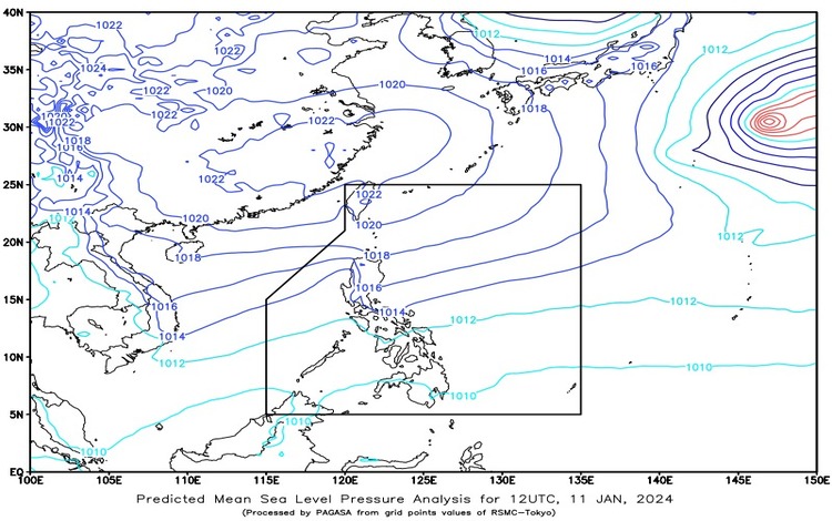
In the Bicol Region, Quezon, and Northern and Eastern Samar, residents can expect cloudy skies with scattered rain showers and thunderstorms. This weather pattern is attributed to the Shear Line, and the potential consequences include possible flash floods or landslides due to moderate to heavy rains. Vigilance and preparedness are advised to mitigate any adverse impacts.
Moving to Cagayan Valley, Apayao, Kalinga, and Aurora, the forecast indicates cloudy skies with light rains. This weather condition is brought about by the Northeast Monsoon, although there are no significant impacts expected. Residents in these areas can anticipate a relatively stable weather situation but are encouraged to stay informed about updates.
For Metro Manila and the rest of Luzon, the outlook is characterized by partly cloudy to cloudy skies with isolated light rains. The Northeast Monsoon is influencing these regions, with no significant impacts anticipated. While residents may experience sporadic light rains, overall conditions are expected to remain relatively stable.
In the rest of the country, including the Visayas and Mindanao, partly cloudy to cloudy skies with isolated rain showers or thunderstorms are expected. The atmospheric influence in these areas is attributed to Easterlies and Localized Thunderstorms. Communities should be prepared for possible flash floods or landslides during severe thunderstorms.
When it comes to wind and coastal water conditions, Northern Luzon and the eastern section of Central Luzon will experience strong winds coming from the Northeast. Coastal waters in these areas are expected to be rough, with wave heights ranging from 2.8 to 4.0 meters. The rest of Luzon will experience moderate to strong winds, with coastal waters ranging from moderate to rough (2.5 to 3.4 meters). Meanwhile, the rest of the country can expect light to moderate winds from the Northeast, with slight to moderate coastal waters (0.6 to 2.5 meters).