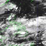
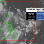
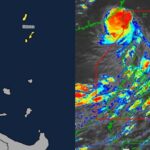
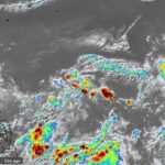
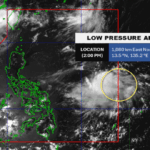
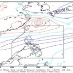
PAGASA Predicts Up to 8 Cyclones in First Half of 2025

Typhoons 2025

The Philippine Atmospheric, Geophysical, and Astronomical Services Administration (PAGASA) has forecast that two to eight tropical cyclones may form within the Philippine Area of Responsibility (PAR) during the first half of 2025. According to PAGASA, the months from January to June are expected to see a relatively low level of cyclone activity, characteristic of the … Read more

PAGASA Weather Forecast: January 4, 2025

Pagasa Weather Update

SYNOPSIS: The Northeast Monsoon is currently affecting Extreme Northern Luzon, while the Shear Line influences Central Luzon and the rest of Northern Luzon. Forecast Weather Conditions Forecast Wind and Coastal Water Conditions Heavy Rainfall Outlook Rainfall is expected to be higher in mountainous and elevated areas. Impacts may worsen in areas with significant antecedent rainfall. … Read more

Pagasa Unveils 2025 Tropical Cyclone Names

Pagasa

The Philippine Atmospheric, Geophysical, and Astronomical Services Administration (Pagasa) has released the list of names for tropical cyclones expected to enter the Philippine Area of Responsibility (PAR) in 2025. This annual practice aims to ensure a standardized naming convention for better public awareness and communication during weather disturbances. 2025 Tropical Cyclone Names Pagasa assigns alphabetical … Read more

Pagasa Weather Forecast: January 2, 2025

Weather Update

The Philippine Atmospheric, Geophysical, and Astronomical Services Administration (PAGASA) has issued its weather forecast for January 2, 2025, highlighting the effects of the Intertropical Convergence Zone (ITCZ), the Shear Line, and the Northeast Monsoon across various parts of the country. Weather Synopsis Forecast Weather Conditions Visayas, Mindanao, Romblon, Catanduanes, Albay, Sorsogon, and Masbate Rest of … Read more

Pagasa Weather Forecast for January 1, 2025

Weather Update

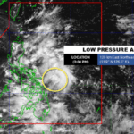
The Philippine Atmospheric, Geophysical and Astronomical Services Administration (Pagasa) has issued a weather forecast for January 1, 2025, highlighting the influence of three major weather systems: the Intertropical Convergence Zone (ITCZ), the Shear Line, and the Northeast Monsoon. These systems are expected to bring varied weather conditions across the country, with potential hazards such as … Read more

Pagasa Weather Forecast for December 28, 2024

Pagasa Weather Update

The Philippine Atmospheric, Geophysical, and Astronomical Services Administration (Pagasa) has issued its latest weather forecast for December 2024, highlighting the combined influence of the Shear Line, Northeast Monsoon, and Intertropical Convergence Zone (ITCZ) across various regions. These weather systems are expected to bring widespread rains, thunderstorms, and potential hazards, prompting advisories for public safety. Weather … Read more

Pagasa Weather Forecast for December 26, 2024

Weather Update Today

The Philippine Atmospheric, Geophysical, and Astronomical Services Administration (Pagasa) has issued the December 26, 2024 weather forecast. Current atmospheric conditions indicate that the Intertropical Convergence Zone (ITCZ) affects Mindanao, while the Northeast Monsoon continues to influence Northern Luzon. Below is a detailed forecast of weather conditions and potential impacts across the country. Weather Conditions Mindanao … Read more

Pagasa Weather Forecast for December 24, 2024

Pagasa Weather Update

Synopsis: The Shear Line continues to affect Southern Luzon and Eastern Visayas, while the Northeast Monsoon influences the rest of Luzon. A Tropical Cyclone, Tropical Storm Pabuk (formerly “Romina”), is located outside the Philippine Area of Responsibility (PAR) as of 3:00 AM today. Tropical Cyclone Details: Forecast Weather Conditions Eastern Visayas, Bicol Region, CALABARZON, and … Read more

Pagasa Update on Tropical Depression Romina

TD Romina

Today December 23, 2024, the Philippine Atmospheric, Geophysical and Astronomical Services Administration (PAGASA) reported that Tropical Depression Romina was located approximately 165 km west of Pag-asa Island, Kalayaan, Palawan, outside the Philippine Area of Responsibility (PAR). Romina moves northwestward at 10 km/h, with maximum sustained winds of 55 km/h near the center and gusts up … Read more

Tropical Depression “Romina” Strengthens as It Moves Northward

Typhoon Romina Update

December 22, 2024, Tropical Depression “Romina” continues to strengthen while moving northward at a speed of 35 km/h. The center of the storm’s eye was estimated at 290 kilometers south of Pag-asa Island, Kalayaan, Palawan, situated outside the Philippine Area of Responsibility (PAR). “Romina” currently carries maximum sustained winds of 55 km/h near its center, … Read more