The weather playbook for early next week is shaping up to be a high-impact scenario, with Meteorologist Robert Speta flagging an emerging low-pressure area (LPA) east of the Philippines that could evolve into a tropical depression between Sunday and Tuesday. Based on his latest technical insights, the operational landscape suggests a need for enhanced preparedness as multiple atmospheric layers converge to amplify rainfall across the country’s eastern corridor.
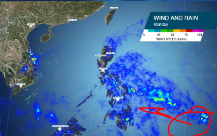
According to Speta, updated ECMWF model runs continue to align around a developing circulation east of Mindanao by Monday. Even before the system enters the Philippine jurisdiction, it’s already positioned to funnel deep moisture inland. This inflow will interact with the persistent shear line over northern Luzon, driving intensified rainfall over Eastern Visayas, particularly Leyte and Samar. Satellite markers—such as a convection burst south of Guam, the subtropical ridge anchoring the north, and a shear line sprawled across Luzon—are collectively steering the disturbance westward toward the archipelago.
Key rainfall hotspots are expected to include Bicol, Leyte, Samar, and eastern Cebu, where sustained precipitation may disrupt local operations and mobility. Metro Manila is projected to see increasing rainfall by Tuesday as moisture continues to funnel into the monsoon flow. Speta notes that Cagayan and Isabela remain high-risk zones due to ongoing shear-line rains, with some areas potentially breaching 200–300 mm of cumulative rainfall.
While many online users focus on GFS-generated maps circulating on social media, Speta clarifies that the heaviest rainfall will likely occur north of the low-pressure center—specifically along the right-front quadrant where moisture consolidates into the Northeast Monsoon. This puts the Visayas and Southern Luzon in a more vulnerable posture compared to Mindanao, despite the system’s point of origin.
The Philippines is not the only market impacted by this meteorological setup. Vietnam is currently executing crisis-response measures due to widespread flooding, and an added disturbance could exacerbate its recovery curve.
Speta emphasizes that although development into a tropical depression remains possible, current indicators show a rain-dominant system rather than a wind-driven hazard. Late-season formations often underperform in terms of wind impact but can still deliver disruptive rainfall—especially in regions still navigating recovery from earlier weather events like Uwan and Tino.
He commits to providing ongoing updates via Western Pacific Weather channels, reinforcing his call for communities to stay weather-aware as conditions evolve.
Stay safe and stay aligned with verified advisories as this system progresses.