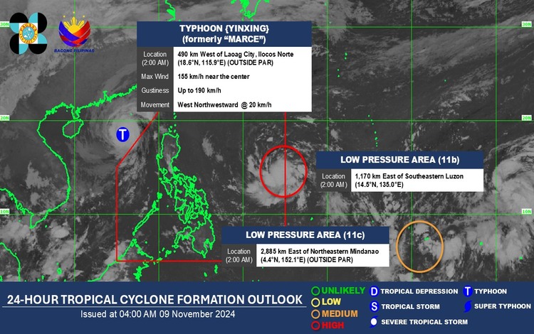
PAGASA issued a weather advisory early Saturday morning regarding a new Low-Pressure Area (LPA) that entered the Philippine Area of Responsibility (PAR) at 2 a.m. This LPA, last tracked 1,170 kilometers east of Southeastern Luzon, has a high chance of developing into a tropical storm within the next 24 hours. If it becomes a tropical cyclone, it will be named “Nica” and tagged as #NicaPH.

According to PAGASA, the current conditions are favorable for this LPA to intensify into a tropical cyclone within the next 12 hours. The weather bureau is closely monitoring its movement as it is expected to bring inclement weather, particularly affecting regions in the eastern part of the country.
Meanwhile, PAGASA is also tracking Typhoon Yinxing, formerly known as Typhoon Marce, which is currently located outside the PAR, approximately 500 kilometers west of Laoag City. This typhoon has sustained winds of 155 kilometers per hour and gusts reaching up to 190 kilometers per hour, moving west-northwest at 20 kilometers per hour. While Typhoon Yinxing is not expected to directly impact the Philippines, it may enhance the southwest monsoon, potentially bringing rain to the western part of the country.
On Saturday, the easterlies and localized thunderstorms will bring partly cloudy to cloudy skies with isolated rain showers or thunderstorms nationwide. PAGASA advises the public to be prepared for sudden rainfall, especially in areas prone to flooding.
With the current weather conditions, PAGASA will continue to release updates to track any developments with the LPA, which may soon become Typhoon Nica. This ensures that the public remains informed and prepared for possible impacts on the country.
