As Typhoon Marce made landfall in the vicinity of Santa Ana, Cagayan this afternoon, the Philippine Atmospheric, Geophysical, and Astronomical Services Administration (Pagasa) issued an urgent update at 5 PM on November 7, 2024, warning of hazardous weather conditions and severe impacts across northern Luzon. The typhoon is currently generating life-threatening conditions across affected regions, with particular danger expected in northeastern Cagayan and surrounding provinces.

Current Location and Intensity
At 4:00 PM, the eye of Typhoon Marce was located in Santa Ana, Cagayan, with coordinates at 18.5°N and 122.0°E. Marce’s maximum sustained winds were recorded at 175 km/h near the center, accompanied by gusts reaching up to 240 km/h. The typhoon has a central pressure of 940 hPa and is moving westward at a speed of 10 km/h. Marce’s strong winds extend outward up to 560 km from the center, impacting a wide area with its powerful reach.
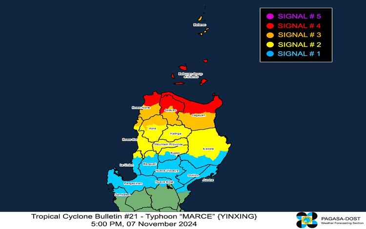
Tropical Cyclone Wind Signals (TCWS)
To ensure public awareness and preparedness, Pagasa has issued a series of Tropical Cyclone Wind Signals (TCWS) across various parts of Luzon:
- TCWS No. 4 is in effect over the northern portion of Cagayan, Babuyan Islands, the northern part of Apayao, and the northern portion of Ilocos Norte. This signal denotes typhoon-force winds with speeds ranging from 118 to 184 km/h. Residents in these areas are advised to brace for severe impacts to life and property, with significant potential for structural damage and hazards.
- TCWS No. 3 covers Batanes, other parts of Cagayan, the rest of Apayao, Ilocos Norte, portions of Abra, and parts of Ilocos Sur. These regions will face storm-force winds, reaching up to 117 km/h, posing moderate to significant threats to property and public safety.
- TCWS No. 2 is declared over portions of Isabela, Abra, Kalinga, Mountain Province, Ifugao, Benguet, Ilocos Sur, and La Union. Winds in these areas will reach gale-force speeds between 62 and 88 km/h, which could result in minor to moderate damage.
- TCWS No. 1 includes the rest of La Union, Pangasinan, additional areas in Isabela, Quirino, Nueva Vizcaya, portions of Aurora, Nueva Ecija, and Zambales. While these areas face strong winds with speeds between 39 and 61 km/h, the impact on life and property is expected to be minimal to minor.

Other Hazards Affecting Land Areas
Heavy Rainfall Outlook
According to Pagasa’s Weather Advisory No. 18, issued at 5:00 PM, heavy rainfall is anticipated in the areas under higher TCWS levels. Residents should prepare for torrential rain, which may lead to severe flooding, flash floods, and landslides in susceptible areas.
Severe Winds
The winds from Typhoon Marce are likely to amplify in coastal and elevated areas. Particularly severe effects from typhoon-force winds are expected in TCWS No. 4 regions, while TCWS No. 3 areas can expect moderate to significant impacts. Coastal and upland areas in Zambales, Bataan, and Polillo Islands today, and in Batanes, Cagayan, Babuyan Islands, Isabela, and the Ilocos Region tomorrow, should brace for strong to gale-force gusts.
Coastal Inundation and Storm Surge
A storm surge warning has been raised, with the potential for peak surge heights exceeding 3.0 meters over low-lying or exposed coastal localities in Batanes, Cagayan, Babuyan Islands, Isabela, Ilocos Norte, Ilocos Sur, and La Union. This surge height poses a severe risk to life and property along these coastal areas, necessitating immediate evacuation for those in danger zones.
Sea Condition and Maritime Advisory
Pagasa has issued a Gale Warning, advising against sea travel in Northern Luzon and the western seaboard of Central Luzon. Sea conditions will range from very rough to extremely hazardous, with waves reaching up to 12 meters in height along the Babuyan Islands and the northern seaboards of Cagayan. All vessels, regardless of size, are advised to remain in port or seek shelter, as seas will remain perilous for navigation.
Track and Intensity Outlook
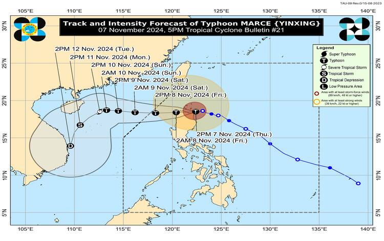
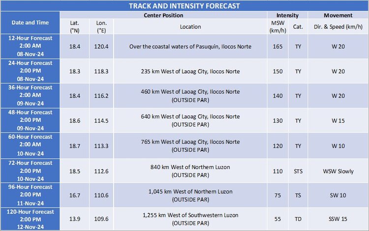
Typhoon Marce is expected to continue its westward path, emerging over Aparri Bay and potentially making a second landfall along the northwestern Cagayan coast tonight. The typhoon will likely move into the West Philippine Sea by early tomorrow morning, November 8, 2024. It will persist as a typhoon throughout its trajectory within the Philippine Area of Responsibility (PAR) despite some weakening due to land interaction and dry air intrusion. There remains a possibility of Marce reaching super typhoon status, but sustained weakening is anticipated once it exits the PAR tomorrow evening.
The storm is expected to be influenced by the northeasterly wind surge over the weekend, prompting a gradual shift to a southwestward track by Sunday, November 10, 2024. Although weakening is projected as the typhoon moves away, continued vigilance is crucial given the scale and intensity of Marce.

Preparedness and Advisory for Residents
Residents in affected areas are strongly urged to heed evacuation orders, stay informed through reliable updates, and avoid venturing into flood-prone or landslide-prone areas. Authorities have been mobilized to respond to emergencies, and local government units are preparing for the potential impact of heavy rain, severe winds, and coastal inundation.
Pagasa will continue to monitor Typhoon Marce and provide updates on its trajectory and strength.
